Located aquifer inventory
Generated by inventory_aquifers.py. Every known aquifer body within 40 km of the site-screen box, with its location.
Generated by inventory_aquifers.py. Every known aquifer body within 40 km of the site-screen box, with its location. No distance to the proposed store appears anywhere in this file.
Why the box and not the store
The store at E330255 N122245 is one candidate location for one component of a scheme that has not been designed. Every previous aquifer table measured from it, and the standing 625k table cuts at 25 km from it - so a design assumption was deciding which geology got into the evidence base at all. The Bridport Sand missed that table by 1.4 km of an assumed radius from an assumed point.
Distances here are measured from dem_bounding_box = E315,000.0-360,000.0 N115,000.0-145,000.0, the ground where an intake or reservoir could actually go. A body that overlaps the box is at 0 km. The box is a data boundary; it does not move when the design does.
This inventory does not rank anything. It locates. Once a real intake or reservoir site exists, call bodies_near(inv, E, N, km) - or python inventory_aquifers.py somerset --site E,N - to assess each body for each role against THAT site.
What is in and what is out
- 335 bodies, 7,887 km2 within 40 km of the box
- Class 3 excluded: 263 polygons. ‘Essentially no groundwater’, and it records no flow mechanism - not an aquifer, so not in an aquifer inventory
- bodies below 0.25 km2 dropped: 126
- polygons are dissolved by unit then split into CONNECTED bodies, so a row is something water could move within - the same compartment rule
aquifer_registry.ymlworks to
COVERAGE GAP, STATED NOT ASSUMED. 2,001 km2 of the 12,368 km2 search halo (16%) falls outside the
bounding_boxthe 625k was downloaded to, so any body there is invisible to this table however close it is to the site box. Widenbounding_boxand re-download to close it. This is the same class of artefact project.yml already records for the borehole and LiDAR boxes: a data box deciding the answer.
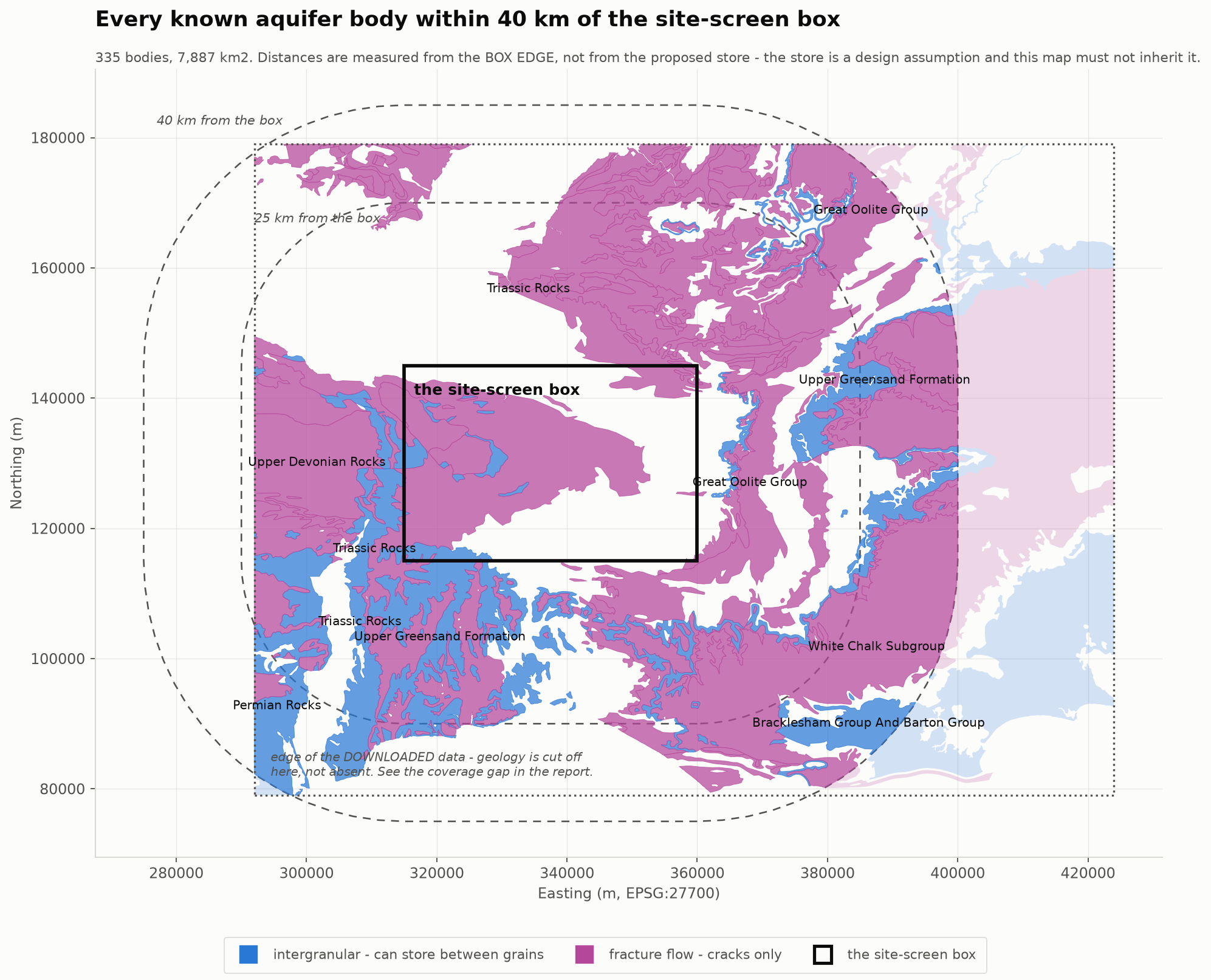
By band and flow mechanism
| band | bodies | km2 | intergranular km2 |
|---|---|---|---|
| overlaps the box | 28 | 1,950 | 510 |
| 0-25 km | 197 | 4,821 | 772 |
| 25-40 km | 110 | 1,116 | 708 |
Intergranular is broken out because it is the only column that decides whether a body can STORE water rather than merely transmit it.
Every body
role is carried from screen_portfolio.py via our own 50k model. A blank our_formation means the 50k screenshot does not reach that body - we have not looked, which is not the same as nothing being there.
nearest to box is the point ON the body closest to the site box - the location to use. For a big body the centroid is meaningless: the White Chalk body spans 71 x 79 km, so its centroid lies about 40 km from the ground where it actually comes near us. Centroid and bounding box are in the CSV for completeness, not for siting.
extent is the longest dimension. Read it against the compartment rule in aquifer_registry.yml: water moves about 16 m through this rock in the 229-day surplus-to-deficit lag, so ANY body here longer than a few km holds several independent stores. No row in this table is one tank, and none of these areas may be multiplied into a capacity.
role is the role of the body’s DOMINANT 50k formation, and #fm counts how many distinct 50k formations we map inside it. Where #fm is greater than 1 the role describes part of the body only - this project’s standing finding is that one 625k polygon can hold 6-9 distinct 50k units, and at least one Class 1A body below is dominated by SEAL. Class and role disagreeing is the mosaic showing through, not an error.
| body | unit | class | flow | km2 | extent | nearest to box | km to box | our 50k formation | #fm | role |
|---|---|---|---|---|---|---|---|---|---|---|
Tri@ST25352525 |
Triassic Rocks (Undifferentiated) | 2C | fractures | 706.0 | 61.1 km | ST1500 4305 | 0.0 | Sidmouth Mudstone Formation | 10 | SEAL |
Tri@ST50815805 |
Triassic Rocks (Undifferentiated) | 2C | fractures | 482.4 | 43.6 km | ST5763 4500 | 0.0 | Sidmouth Mudstone Formation | 9 | SEAL |
UppGre@ST20490513 |
Upper Greensand Formation | 1B | intergranular | 287.6 | 30.1 km | ST1941 1500 | 0.0 | - | - | - |
Tri@ST08780367 |
Triassic Rocks (Undifferentiated) | 1A | intergranular | 177.5 | 48.1 km | ST1517 2805 | 0.0 | Helsby Sandstone Formation | 5 | STORE |
Tri@SY24639932 |
Triassic Rocks (Undifferentiated) | 2C | fractures | 109.2 | 25.7 km | ST2628 1500 | 0.0 | - | - | - |
MidDev@ST17353685 |
Middle Devonian (Undifferentiated) | 2C | fractures | 58.9 | 13.9 km | ST1806 3829 | 0.0 | Sidmouth Mudstone Formation | 5 | SEAL |
UppDev@ST24363115 |
Upper Devonian Rocks (Undifferentiated) | 2C | fractures | 37.8 | 9.8 km | ST2257 2885 | 0.0 | Morte Slates Formation | 4 | CATCHMENT |
InfOol@ST64131920 |
Inferior Oolite Group | 2A | fractures | 32.0 | 12.3 km | ST6000 1500 | 0.0 | Wiveliscombe Sandstones | 1 | CONJUNCTIVE |
Tri@ST15333205 |
Triassic Rocks (Undifferentiated) | 1A | intergranular | 21.9 | 8.3 km | ST1500 3337 | 0.0 | Helsby Sandstone Formation | 6 | STORE |
Tri@ST28583063 |
Triassic Rocks (Undifferentiated) | 1A | intergranular | 11.6 | 7.0 km | ST2822 3093 | 0.0 | Helsby Sandstone Formation | 4 | STORE |
Tri@ST19053827 |
Triassic Rocks (Undifferentiated) | 1A | intergranular | 3.3 | 3.4 km | ST2058 3914 | 0.0 | Sidmouth Mudstone Formation | 2 | SEAL |
Tri@ST32152578 |
Triassic Rocks (Undifferentiated) | 1A | intergranular | 2.6 | 4.7 km | ST2955 2531 | 0.0 | Sidmouth Mudstone Formation | 1 | SEAL |
Tri@ST38603918 |
Triassic Rocks (Undifferentiated) | 2C | fractures | 2.3 | 4.5 km | ST3704 3985 | 0.0 | Blue Lias Formation | 2 | INERT |
Din@ST58054517 |
Dinantian Rocks (Undifferentiated) | 2B | fractures | 2.0 | 5.1 km | ST5941 4462 | 0.0 | Blue Lias Formation | 3 | INERT |
Tri@ST58964443 |
Triassic Rocks (Undifferentiated) | 2B | fractures | 1.8 | 3.1 km | ST5833 4426 | 0.0 | Blue Lias Formation | 3 | INERT |
Tri@ST59312533 |
Triassic Rocks (Undifferentiated) | 2C | fractures | 1.8 | 4.6 km | ST5696 2557 | 0.0 | Blue Lias Formation | 2 | INERT |
Tri@ST23292783 |
Triassic Rocks (Undifferentiated) | 1A | intergranular | 1.5 | 1.9 km | ST2309 2711 | 0.0 | Morte Slates Formation | 3 | CATCHMENT |
Tri@ST26763918 |
Triassic Rocks (Undifferentiated) | 1A | intergranular | 1.3 | 2.2 km | ST2565 3945 | 0.0 | Sidmouth Mudstone Formation | 2 | SEAL |
Din@ST57664362 |
Dinantian Rocks (Undifferentiated) | 2B | fractures | 1.3 | 2.7 km | ST5846 4353 | 0.0 | Branscombe Mudstone Formation | 2 | SEAL |
Tri@ST59554242 |
Triassic Rocks (Undifferentiated) | 2B | fractures | 1.1 | 2.4 km | ST5970 4277 | 0.0 | Blue Lias Formation | 2 | INERT |
Tri@ST27543784 |
Triassic Rocks (Undifferentiated) | 1A | intergranular | 1.1 | 2.7 km | ST2637 3809 | 0.0 | Sidmouth Mudstone Formation | 2 | SEAL |
Hol@ST24753984 |
Holsworthy Group | 2C | fractures | 0.9 | 3.2 km | ST2568 3980 | 0.0 | Sidmouth Mudstone Formation | 1 | SEAL |
Tri@ST21152975 |
Triassic Rocks (Undifferentiated) | 1A | intergranular | 0.9 | 1.6 km | ST2065 2983 | 0.0 | Morte Slates Formation | 2 | CATCHMENT |
MidDev@ST21713863 |
Middle Devonian (Undifferentiated) | 2C | fractures | 0.8 | 2.0 km | ST2104 3837 | 0.0 | Sidmouth Mudstone Formation | 2 | SEAL |
Tri@ST24784016 |
Triassic Rocks (Undifferentiated) | 1A | intergranular | 0.7 | 2.8 km | ST2407 4036 | 0.0 | Sidmouth Mudstone Formation | 1 | SEAL |
Tri@ST22123679 |
Triassic Rocks (Undifferentiated) | 1A | intergranular | 0.5 | 1.6 km | ST2274 3697 | 0.0 | Sidmouth Mudstone Formation | 2 | SEAL |
Din@ST24664056 |
Dinantian Rocks (Undifferentiated) | 2B | fractures | 0.5 | 1.2 km | ST2503 4070 | 0.0 | Sidmouth Mudstone Formation | 1 | SEAL |
LowDev@ST15243598 |
Lower Devonian Rocks (Undifferentiated) | 2C | fractures | 0.4 | 1.0 km | ST1545 3608 | 0.0 | Trentishoe Member | 1 | BOUNDARY |
InfOol@ST40781402 |
Inferior Oolite Group | 2A | fractures | 1.4 | 3.2 km | ST3937 1472 | 0.3 | - | - | - |
Din@ST64314731 |
Dinantian Rocks (Undifferentiated) | 2B | fractures | 24.9 | 18.3 km | ST6036 4510 | 0.4 | Clifton Down Limestone Formation | 6 | CATCHMENT |
GreOol@ST65142667 |
Great Oolite Group | 2B | fractures | 407.7 | 70.2 km | ST6021 1462 | 0.4 | Langport Mbr, Blue Lias Fm and Charmouth Mudstone Fm (undifferentiated) | 3 | - |
Tri@ST56104672 |
Triassic Rocks (Undifferentiated) | 2B | fractures | 2.6 | 3.4 km | ST5679 4590 | 0.9 | Blue Lias Formation | 4 | INERT |
InfOol@ST54471321 |
Inferior Oolite Group | 2A | fractures | 0.6 | 1.6 km | ST5428 1359 | 1.4 | - | - | - |
InfOol@ST47201300 |
Inferior Oolite Group | 2A | fractures | 0.9 | 2.5 km | ST4623 1356 | 1.4 | - | - | - |
Tri@ST50334954 |
Triassic Rocks (Undifferentiated) | 2B | fractures | 10.3 | 7.4 km | ST5187 4661 | 1.6 | Sidmouth Mudstone Formation | 4 | SEAL |
Din@ST50545352 |
Dinantian Rocks (Undifferentiated) | 2B | fractures | 81.3 | 24.5 km | ST5415 4662 | 1.6 | Sidmouth Mudstone Formation | 6 | SEAL |
Tri@ST55914694 |
Triassic Rocks (Undifferentiated) | 2C | fractures | 0.4 | 1.0 km | ST5563 4665 | 1.7 | Clifton Down Limestone Formation | 1 | CATCHMENT |
Per@ST11453391 |
Permian Rocks (Undifferentiated) | 1B | intergranular | 15.5 | 9.6 km | ST1327 3224 | 1.7 | Wiveliscombe Sandstones | 4 | CONJUNCTIVE |
UppDev@ST66144646 |
Upper Devonian Rocks (Undifferentiated) | 2C | fractures | 8.1 | 12.1 km | ST6116 4678 | 2.1 | Portishead Subgroup | 2 | BOUNDARY |
BriSan@ST66013232 |
Bridport Sand Formation | 1B | intergranular | 16.9 | 16.5 km | ST6216 2503 | 2.2 | Wiveliscombe Sandstones | 3 | CONJUNCTIVE |
GreCha@ST30670816 |
Grey Chalk Subgroup | 2A | fractures | 10.8 | 8.6 km | ST2907 1275 | 2.2 | - | - | - |
InfOol@ST44271223 |
Inferior Oolite Group | 2A | fractures | 0.3 | 1.1 km | ST4494 1253 | 2.5 | - | - | - |
UppDev@ST57274853 |
Upper Devonian Rocks (Undifferentiated) | 2C | fractures | 3.7 | 5.5 km | ST5660 4749 | 2.5 | Portishead Subgroup | 2 | BOUNDARY |
GreOol@ST41541205 |
Great Oolite Group | 2B | fractures | 0.7 | 2.7 km | ST4055 1229 | 2.7 | - | - | - |
Tri@ST10052531 |
Triassic Rocks (Undifferentiated) | 2C | fractures | 8.7 | 8.7 km | ST1209 2076 | 2.9 | Black Ven Marl Member | 5 | INERT |
Tri@ST64205005 |
Triassic Rocks (Undifferentiated) | 2B | fractures | 12.0 | 8.3 km | ST5945 4796 | 3.0 | Sidmouth Mudstone Formation | 3 | SEAL |
GreCha@ST31241166 |
Grey Chalk Subgroup | 2A | fractures | 0.5 | 1.0 km | ST3098 1201 | 3.0 | - | - | - |
BriSan@ST63904251 |
Bridport Sand Formation | 1B | intergranular | 1.7 | 3.2 km | ST6308 4148 | 3.1 | Wiveliscombe Sandstones | 2 | CONJUNCTIVE |
InfOol@ST45891139 |
Inferior Oolite Group | 2A | fractures | 0.5 | 1.1 km | ST4587 1190 | 3.1 | - | - | - |
UppDev@ST01323018 |
Upper Devonian Rocks (Undifferentiated) | 2C | fractures | 246.2 | 19.9 km | ST1189 2913 | 3.1 | Morte Slates Formation | 4 | CATCHMENT |
InfOol@ST65664271 |
Inferior Oolite Group | 2A | fractures | 7.6 | 5.9 km | ST6346 4179 | 3.5 | Wiveliscombe Sandstones | 4 | CONJUNCTIVE |
InfOol@ST47011029 |
Inferior Oolite Group | 2A | fractures | 2.0 | 1.9 km | ST4701 1109 | 3.9 | - | - | - |
UppGre@ST37740813 |
Upper Greensand Formation | 1B | intergranular | 17.1 | 7.1 km | ST3586 1099 | 4.0 | - | - | - |
InfOol@ST66033032 |
Inferior Oolite Group | 2A | fractures | 7.7 | 7.2 km | ST6408 3134 | 4.1 | Wiveliscombe Sandstones | 2 | CONJUNCTIVE |
Per@ST09042716 |
Permian Rocks (Undifferentiated) | 1B | intergranular | 6.8 | 4.6 km | ST1085 2669 | 4.1 | Morte Slates Formation | 4 | CATCHMENT |
UnnExtSil@ST66674583 |
Unnamed Extrusive Rocks, Silurian | 2C | fractures | 2.2 | 4.6 km | ST6426 4550 | 4.3 | Portishead Subgroup | 1 | BOUNDARY |
GreOol@ST65092042 |
Great Oolite Group | 2B | fractures | 0.8 | 1.8 km | ST6460 2091 | 4.6 | - | - | - |
UppDev@ST67104517 |
Upper Devonian Rocks (Undifferentiated) | 2C | fractures | 3.4 | 4.2 km | ST6462 4524 | 4.6 | Portishead Subgroup | 1 | BOUNDARY |
Tri@ST56025117 |
Triassic Rocks (Undifferentiated) | 2B | fractures | 2.8 | 3.5 km | ST5687 4964 | 4.6 | Sidmouth Mudstone Formation | 3 | SEAL |
WhiCha@ST38110866 |
White Chalk Subgroup | 2A | fractures | 7.2 | 5.2 km | ST3666 1021 | 4.8 | - | - | - |
Tri@ST06433981 |
Triassic Rocks (Undifferentiated) | 1A | intergranular | 11.4 | 8.1 km | ST1021 3839 | 4.8 | Sidmouth Mudstone Formation | 2 | SEAL |
Din@ST65824466 |
Dinantian Rocks (Undifferentiated) | 2B | fractures | 0.9 | 1.8 km | ST6489 4480 | 4.9 | Portishead Subgroup | 2 | BOUNDARY |
Tri@ST09192411 |
Triassic Rocks (Undifferentiated) | 1A | intergranular | 0.8 | 1.4 km | ST1001 2375 | 5.0 | Black Ven Marl Member | 1 | INERT |
Tri@ST64414819 |
Triassic Rocks (Undifferentiated) | 2B | fractures | 0.4 | 0.9 km | ST6407 4792 | 5.0 | Black Ven Marl Member | 1 | INERT |
PenLowCoa@ST67734871 |
Pennine Lower Coal Measures Formation And South Wales Lower Coal Measures Formation (Undifferentiated) | 2B | fractures | 9.0 | 7.6 km | ST6374 4856 | 5.2 | Black Ven Marl Member | 2 | INERT |
InfOol@ST45330808 |
Inferior Oolite Group | 2A | fractures | 5.0 | 4.0 km | ST4427 0975 | 5.2 | - | - | - |
BriSan@ST65694098 |
Bridport Sand Formation | 1B | intergranular | 0.3 | 1.0 km | ST6534 4138 | 5.3 | - | - | - |
UppDev@ST54585120 |
Upper Devonian Rocks (Undifferentiated) | 2C | fractures | 1.9 | 2.7 km | ST5473 5058 | 5.6 | Sidmouth Mudstone Formation | 2 | SEAL |
MidDev@SS97924080 |
Middle Devonian (Undifferentiated) | 2C | fractures | 89.9 | 17.3 km | ST0931 3795 | 5.7 | Sidmouth Mudstone Formation | 2 | SEAL |
Tri@ST63025107 |
Triassic Rocks (Undifferentiated) | 2C | fractures | 2.3 | 2.5 km | ST6231 5052 | 6.0 | Sidmouth Mudstone Formation | 2 | SEAL |
GreOol@ST66312132 |
Great Oolite Group | 2B | fractures | 0.8 | 2.0 km | ST6602 2122 | 6.0 | - | - | - |
BriSan@ST67264000 |
Bridport Sand Formation | 1B | intergranular | 1.0 | 1.8 km | ST6637 4065 | 6.4 | - | - | - |
UppDev@ST57095183 |
Upper Devonian Rocks (Undifferentiated) | 2C | fractures | 0.7 | 1.1 km | ST5696 5138 | 6.4 | Clifton Down Limestone Formation | 2 | CATCHMENT |
Din@ST57475270 |
Dinantian Rocks (Undifferentiated) | 2B | fractures | 3.5 | 3.3 km | ST5781 5140 | 6.4 | Sidmouth Mudstone Formation | 2 | SEAL |
Tri@ST56355203 |
Triassic Rocks (Undifferentiated) | 2B | fractures | 0.7 | 1.1 km | ST5675 5141 | 6.4 | Clifton Down Limestone Formation | 1 | CATCHMENT |
InfOol@ST67204035 |
Inferior Oolite Group | 2A | fractures | 0.7 | 1.6 km | ST6643 4071 | 6.4 | - | - | - |
InfOol@ST68423708 |
Inferior Oolite Group | 2A | fractures | 6.1 | 9.6 km | ST6650 3577 | 6.5 | Wiveliscombe Sandstones | 1 | CONJUNCTIVE |
PenMidCoa@ST68344972 |
Pennine Middle Coal Measures Formation And South Wales Middle Coal Measures Formation (Undifferentiated) | 2B | fractures | 3.6 | 5.7 km | ST6548 4883 | 6.7 | Black Ven Marl Member | 1 | INERT |
Din@ST06011892 |
Dinantian Rocks (Undifferentiated) | 2B | fractures | 3.7 | 5.2 km | ST0828 1938 | 6.7 | - | - | - |
UppGre@ST42930717 |
Upper Greensand Formation | 1B | intergranular | 1.9 | 2.1 km | ST4307 0824 | 6.8 | - | - | - |
Per@ST07311810 |
Permian Rocks (Undifferentiated) | 1B | intergranular | 0.6 | 1.4 km | ST0796 1853 | 7.0 | - | - | - |
GreOol@ST41530734 |
Great Oolite Group | 2B | fractures | 1.3 | 1.5 km | ST4105 0795 | 7.0 | - | - | - |
TeiVal@ST05532082 |
Teign Valley Group | 2C | fractures | 5.1 | 5.1 km | ST0790 2142 | 7.1 | - | - | - |
Tri@ST08001069 |
Triassic Rocks (Undifferentiated) | 2C | fractures | 1.1 | 1.9 km | ST0889 1100 | 7.3 | - | - | - |
Cor@ST66260752 |
Corallian Group | 2B | fractures | 16.9 | 6.8 km | ST6406 0884 | 7.4 | - | - | - |
GreCha@ST42880704 |
Grey Chalk Subgroup | 2A | fractures | 0.5 | 0.9 km | ST4295 0744 | 7.6 | - | - | - |
UppGre@ST63910434 |
Upper Greensand Formation | 1B | intergranular | 8.3 | 8.1 km | ST5945 0734 | 7.7 | - | - | - |
GreCha@ST63480213 |
Grey Chalk Subgroup | 2A | fractures | 20.5 | 13.1 km | ST5924 0703 | 8.0 | - | - | - |
Din@ST06011712 |
Dinantian Rocks (Undifferentiated) | 2B | fractures | 0.8 | 2.1 km | ST0698 1748 | 8.0 | - | - | - |
UppGre@ST44870611 |
Upper Greensand Formation | 1B | intergranular | 1.5 | 1.9 km | ST4517 0697 | 8.0 | - | - | - |
Tri@ST51615376 |
Triassic Rocks (Undifferentiated) | 2B | fractures | 3.0 | 4.2 km | ST5210 5303 | 8.0 | Sidmouth Mudstone Formation | 3 | SEAL |
UppGre@ST53990075 |
Upper Greensand Formation | 1B | intergranular | 44.8 | 16.5 km | ST4939 0682 | 8.2 | - | - | - |
Din@ST70124525 |
Dinantian Rocks (Undifferentiated) | 2B | fractures | 6.9 | 4.1 km | ST6825 4418 | 8.3 | - | - | - |
War@ST67485055 |
Warwickshire Group | 2B | fractures | 1.5 | 2.5 km | ST6673 4978 | 8.3 | Blue Lias Formation | 1 | INERT |
Tri@ST55245568 |
Triassic Rocks (Undifferentiated) | 2B | fractures | 6.2 | 4.8 km | ST5393 5326 | 8.3 | Sidmouth Mudstone Formation | 1 | SEAL |
Din@SS98122240 |
Dinantian Rocks (Undifferentiated) | 2B | fractures | 17.1 | 13.9 km | ST0594 2089 | 9.1 | - | - | - |
InfOol@ST72624562 |
Inferior Oolite Group | 2A | fractures | 4.7 | 5.9 km | ST6931 4367 | 9.3 | - | - | - |
GreCha@ST57490316 |
Grey Chalk Subgroup | 2A | fractures | 4.9 | 4.5 km | ST5660 0558 | 9.4 | - | - | - |
Hol@SS97391913 |
Holsworthy Group | 2C | fractures | 68.4 | 13.6 km | ST0558 1858 | 9.4 | - | - | - |
GreCha@ST53620158 |
Grey Chalk Subgroup | 2A | fractures | 29.3 | 12.2 km | ST4916 0556 | 9.4 | - | - | - |
Hol@ST04431533 |
Holsworthy Group | 2C | fractures | 1.0 | 2.0 km | ST0550 1518 | 9.5 | - | - | - |
GreCha@ST27880413 |
Grey Chalk Subgroup | 2A | fractures | 1.9 | 3.2 km | ST2762 0541 | 9.6 | - | - | - |
GreCha@ST58220450 |
Grey Chalk Subgroup | 2A | fractures | 1.2 | 1.9 km | ST5719 0539 | 9.6 | - | - | - |
UppGre@ST42780478 |
Upper Greensand Formation | 1B | intergranular | 0.4 | 1.1 km | ST4235 0517 | 9.8 | - | - | - |
UppGre@ST36810276 |
Upper Greensand Formation | 1B | intergranular | 8.8 | 4.6 km | ST3688 0510 | 9.9 | - | - | - |
GreCha@ST54190467 |
Grey Chalk Subgroup | 2A | fractures | 0.3 | 0.8 km | ST5401 0507 | 9.9 | - | - | - |
UppGre@ST39810259 |
Upper Greensand Formation | 1B | intergranular | 3.0 | 3.8 km | ST3867 0471 | 10.3 | - | - | - |
UppGre@ST17710415 |
Upper Greensand Formation | 1B | intergranular | 0.4 | 0.9 km | ST1786 0463 | 10.4 | - | - | - |
Per@SS98621181 |
Permian Rocks (Undifferentiated) | 1B | intergranular | 70.8 | 12.5 km | ST0446 1646 | 10.5 | - | - | - |
Din@ST35495751 |
Dinantian Rocks (Undifferentiated) | 2B | fractures | 8.1 | 5.1 km | ST3687 5561 | 10.6 | Sidmouth Mudstone Formation | 3 | SEAL |
UppGre@ST89042065 |
Upper Greensand Formation | 1B | intergranular | 89.0 | 38.4 km | ST6841 0827 | 10.8 | - | - | - |
UppGre@ST43600381 |
Upper Greensand Formation | 1B | intergranular | 0.4 | 1.3 km | ST4365 0421 | 10.8 | - | - | - |
WhiCha@ST96612197 |
White Chalk Subgroup | 2A | fractures | 1,959.0 | 79.3 km | ST6096 0419 | 10.8 | - | - | - |
WhiCha@ST36790360 |
White Chalk Subgroup | 2A | fractures | 0.5 | 0.9 km | ST3700 0406 | 10.9 | - | - | - |
UppDev@ST47445686 |
Upper Devonian Rocks (Undifferentiated) | 2C | fractures | 5.5 | 7.7 km | ST4980 5599 | 11.0 | Clifton Down Limestone Formation | 4 | CATCHMENT |
Tri@ST37635750 |
Triassic Rocks (Undifferentiated) | 2B | fractures | 1.4 | 2.6 km | ST3731 5603 | 11.0 | Sidmouth Mudstone Formation | 1 | SEAL |
WhiCha@ST68860748 |
White Chalk Subgroup | 2A | fractures | 0.3 | 1.2 km | ST6879 0799 | 11.2 | - | - | - |
Per@ST03351803 |
Permian Rocks (Undifferentiated) | 1B | intergranular | 0.3 | 0.8 km | ST0370 1830 | 11.3 | - | - | - |
Tri@ST44195768 |
Triassic Rocks (Undifferentiated) | 2B | fractures | 6.2 | 4.9 km | ST4263 5631 | 11.3 | Sidmouth Mudstone Formation | 3 | SEAL |
InfOol@ST75045469 |
Inferior Oolite Group | 2A | fractures | 20.6 | 20.4 km | ST7013 5006 | 11.3 | - | - | - |
War@ST63385823 |
Warwickshire Group | 2B | fractures | 7.3 | 5.6 km | ST6338 5583 | 11.4 | Sidmouth Mudstone Formation | 3 | SEAL |
Tri@ST71744886 |
Triassic Rocks (Undifferentiated) | 2B | fractures | 1.5 | 2.2 km | ST7085 4901 | 11.6 | - | - | - |
Din@ST72804528 |
Dinantian Rocks (Undifferentiated) | 2B | fractures | 1.0 | 2.0 km | ST7162 4427 | 11.6 | - | - | - |
GreCha@ST62910082 |
Grey Chalk Subgroup | 2A | fractures | 6.6 | 5.9 km | ST6247 0351 | 11.8 | - | - | - |
GreOol@ST55710270 |
Great Oolite Group | 2B | fractures | 0.3 | 1.0 km | ST5563 0321 | 11.8 | - | - | - |
Tri@ST30235777 |
Triassic Rocks (Undifferentiated) | 2C | fractures | 2.3 | 1.8 km | ST3059 5689 | 11.9 | Morte Slates Formation | 3 | CATCHMENT |
UppGre@ST25390160 |
Upper Greensand Formation | 1B | intergranular | 1.7 | 3.0 km | ST2517 0307 | 11.9 | - | - | - |
Tri@ST49965860 |
Triassic Rocks (Undifferentiated) | 2B | fractures | 4.9 | 6.0 km | ST5269 5709 | 12.1 | Sidmouth Mudstone Formation | 3 | SEAL |
InfOol@ST42890243 |
Inferior Oolite Group | 2A | fractures | 0.4 | 1.3 km | ST4295 0270 | 12.3 | - | - | - |
GreOol@ST56860206 |
Great Oolite Group | 2B | fractures | 0.3 | 1.0 km | ST5692 0260 | 12.4 | - | - | - |
Cor@ST76781892 |
Corallian Group | 2B | fractures | 73.5 | 26.8 km | ST7015 0781 | 12.4 | - | - | - |
Per@ST01971700 |
Permian Rocks (Undifferentiated) | 1B | intergranular | 0.4 | 0.9 km | ST0242 1724 | 12.6 | - | - | - |
InfOol@ST66985656 |
Inferior Oolite Group | 2A | fractures | 0.8 | 2.5 km | ST6602 5609 | 12.6 | Morte Slates Formation | 1 | CATCHMENT |
InfOol@ST45130172 |
Inferior Oolite Group | 2A | fractures | 0.5 | 1.1 km | ST4473 0205 | 12.9 | - | - | - |
Tri@ST39205830 |
Triassic Rocks (Undifferentiated) | 2B | fractures | 0.7 | 1.9 km | ST3966 5807 | 13.1 | Sidmouth Mudstone Formation | 1 | SEAL |
TeiVal@SS98002308 |
Teign Valley Group | 2C | fractures | 3.8 | 8.1 km | ST0171 2196 | 13.3 | - | - | - |
UppGre@ST43540126 |
Upper Greensand Formation | 1B | intergranular | 0.5 | 1.0 km | ST4309 0165 | 13.3 | - | - | - |
Din@ST39455883 |
Dinantian Rocks (Undifferentiated) | 2B | fractures | 1.6 | 3.1 km | ST3829 5847 | 13.5 | Sidmouth Mudstone Formation | 1 | SEAL |
Din@ST29245899 |
Dinantian Rocks (Undifferentiated) | 2B | fractures | 1.1 | 2.6 km | ST2950 5848 | 13.5 | Morte Slates Formation | 1 | CATCHMENT |
InfOol@ST71445751 |
Inferior Oolite Group | 2A | fractures | 9.4 | 8.3 km | ST6779 5607 | 13.5 | - | - | - |
UppGre@ST97845163 |
Upper Greensand Formation | 1B | intergranular | 222.7 | 49.9 km | ST7411 3509 | 14.1 | - | - | - |
UppGre@SY32229542 |
Upper Greensand Formation | 1B | intergranular | 43.5 | 12.0 km | ST3323 0086 | 14.1 | - | - | - |
Tri@ST55246046 |
Triassic Rocks (Undifferentiated) | 2B | fractures | 1.8 | 2.3 km | ST5427 5915 | 14.1 | Sidmouth Mudstone Formation | 2 | SEAL |
Cor@ST73090892 |
Corallian Group | 2B | fractures | 0.3 | 0.7 km | ST7281 0899 | 14.2 | - | - | - |
Hol@SS95230823 |
Holsworthy Group | 2C | fractures | 49.2 | 11.6 km | ST0348 0676 | 14.2 | - | - | - |
GreCha@SY20749955 |
Grey Chalk Subgroup | 2A | fractures | 1.4 | 2.5 km | ST2094 0074 | 14.3 | - | - | - |
InfOol@SY49519952 |
Inferior Oolite Group | 2A | fractures | 1.5 | 1.8 km | ST4968 0029 | 14.7 | - | - | - |
Cor@ST78924099 |
Corallian Group | 2B | fractures | 6.5 | 7.9 km | ST7473 3607 | 14.7 | - | - | - |
Tri@ST49756092 |
Triassic Rocks (Undifferentiated) | 2B | fractures | 3.1 | 5.5 km | ST5174 6008 | 15.1 | Sidmouth Mudstone Formation | 2 | SEAL |
Tri@SS98144611 |
Triassic Rocks (Undifferentiated) | 1A | intergranular | 2.1 | 3.6 km | SS9978 4566 | 15.2 | - | - | - |
Per@SX96169239 |
Permian Rocks (Undifferentiated) | 1B | intergranular | 149.2 | 26.6 km | ST0309 0500 | 15.5 | - | - | - |
Tri@ST44486152 |
Triassic Rocks (Undifferentiated) | 2B | fractures | 2.4 | 4.1 km | ST4269 6064 | 15.6 | Sidmouth Mudstone Formation | 1 | SEAL |
Din@SS98022471 |
Dinantian Rocks (Undifferentiated) | 2B | fractures | 0.5 | 2.3 km | SS9925 2463 | 15.7 | - | - | - |
UppGre@SY25869787 |
Upper Greensand Formation | 1B | intergranular | 1.9 | 2.7 km | SY2540 9905 | 15.9 | - | - | - |
GreOol@ST72685828 |
Great Oolite Group | 2B | fractures | 5.8 | 5.9 km | ST6989 5751 | 16.0 | - | - | - |
Per@SS97811902 |
Permian Rocks (Undifferentiated) | 1B | intergranular | 1.8 | 2.3 km | SS9902 1914 | 16.0 | - | - | - |
War@ST63216382 |
Warwickshire Group | 2B | fractures | 12.6 | 7.0 km | ST6030 6136 | 16.4 | Sidmouth Mudstone Formation | 1 | SEAL |
InfOol@ST73406186 |
Inferior Oolite Group | 2A | fractures | 11.9 | 10.5 km | ST6838 5923 | 16.5 | - | - | - |
Din@ST33096263 |
Dinantian Rocks (Undifferentiated) | 2B | fractures | 6.0 | 5.5 km | ST3260 6156 | 16.6 | - | - | - |
Tri@ST51776317 |
Triassic Rocks (Undifferentiated) | 2B | fractures | 9.4 | 11.3 km | ST5373 6174 | 16.7 | - | - | - |
GreOol@ST74436186 |
Great Oolite Group | 2B | fractures | 13.4 | 9.0 km | ST6952 5940 | 17.3 | - | - | - |
InfOol@SY51849692 |
Inferior Oolite Group | 2A | fractures | 1.1 | 1.9 km | SY5200 9762 | 17.4 | - | - | - |
Hol@ST00970051 |
Holsworthy Group | 2C | fractures | 12.5 | 4.9 km | ST0332 0210 | 17.4 | - | - | - |
Tri@SS94364262 |
Triassic Rocks (Undifferentiated) | 2C | fractures | 5.5 | 5.1 km | SS9745 4220 | 17.5 | - | - | - |
Din@ST48976527 |
Dinantian Rocks (Undifferentiated) | 2B | fractures | 23.6 | 9.7 km | ST5042 6276 | 17.8 | - | - | - |
GreCha@ST79753755 |
Grey Chalk Subgroup | 2A | fractures | 3.3 | 3.6 km | ST7781 3762 | 17.8 | - | - | - |
BriSan@ST71206251 |
Bridport Sand Formation | 1B | intergranular | 1.9 | 4.5 km | ST6979 5994 | 17.9 | - | - | - |
GreCha@ST77670298 |
Grey Chalk Subgroup | 2A | fractures | 8.8 | 6.6 km | ST7361 0336 | 17.9 | - | - | - |
Tri@ST51506393 |
Triassic Rocks (Undifferentiated) | 2C | fractures | 1.1 | 3.1 km | ST5211 6323 | 18.2 | - | - | - |
GreCha@ST73570193 |
Grey Chalk Subgroup | 2A | fractures | 0.8 | 1.5 km | ST7328 0245 | 18.3 | - | - | - |
BriSan@ST69346268 |
Bridport Sand Formation | 1B | intergranular | 2.3 | 3.1 km | ST6767 6184 | 18.5 | - | - | - |
Per@ST00890220 |
Permian Rocks (Undifferentiated) | 1B | intergranular | 0.3 | 0.8 km | ST0115 0256 | 18.6 | - | - | - |
Din@ST52836398 |
Dinantian Rocks (Undifferentiated) | 2B | fractures | 0.4 | 0.9 km | ST5292 6363 | 18.6 | - | - | - |
InfOol@ST69076263 |
Inferior Oolite Group | 2A | fractures | 0.8 | 2.3 km | ST6802 6200 | 18.8 | - | - | - |
GreCha@ST97954772 |
Grey Chalk Subgroup | 2A | fractures | 112.0 | 45.0 km | ST7897 3454 | 19.0 | - | - | - |
UppGre@ST79824433 |
Upper Greensand Formation | 1B | intergranular | 0.8 | 1.3 km | ST7904 4406 | 19.0 | - | - | - |
InfOol@SY50719504 |
Inferior Oolite Group | 2A | fractures | 2.1 | 2.3 km | SY5048 9594 | 19.1 | - | - | - |
UppGre@SY56699501 |
Upper Greensand Formation | 1B | intergranular | 1.8 | 2.7 km | SY5773 9586 | 19.1 | - | - | - |
BriSan@ST79216584 |
Bridport Sand Formation | 1B | intergranular | 11.4 | 15.7 km | ST7279 5944 | 19.3 | - | - | - |
Cor@ST79793151 |
Corallian Group | 2B | fractures | 0.3 | 0.9 km | ST7930 3154 | 19.3 | - | - | - |
BriSan@ST57346625 |
Bridport Sand Formation | 1B | intergranular | 2.6 | 6.0 km | ST5707 6506 | 20.1 | - | - | - |
UppGre@SY40409437 |
Upper Greensand Formation | 1B | intergranular | 0.5 | 1.1 km | SY4046 9493 | 20.1 | - | - | - |
InfOol@ST57126632 |
Inferior Oolite Group | 2A | fractures | 4.2 | 5.4 km | ST5747 6533 | 20.3 | - | - | - |
Per@SY01539868 |
Permian Rocks (Undifferentiated) | 1B | intergranular | 0.6 | 1.3 km | SY0186 9945 | 20.4 | - | - | - |
UppGre@SY21669413 |
Upper Greensand Formation | 1B | intergranular | 0.3 | 0.9 km | SY2185 9444 | 20.6 | - | - | - |
UnnExtPer@SS93651554 |
Unnamed Extrusive Rocks, Permian | 2C | fractures | 0.6 | 1.2 km | SS9423 1577 | 20.8 | - | - | - |
Din@ST33896634 |
Dinantian Rocks (Undifferentiated) | 2B | fractures | 1.3 | 3.2 km | ST3255 6581 | 20.8 | - | - | - |
Tri@ST49196768 |
Triassic Rocks (Undifferentiated) | 2B | fractures | 4.6 | 6.9 km | ST4622 6601 | 21.0 | - | - | - |
UppGre@SY38769337 |
Upper Greensand Formation | 1B | intergranular | 1.4 | 2.6 km | SY3973 9389 | 21.1 | - | - | - |
Din@ST11036625 |
Dinantian Rocks (Undifferentiated) | 2B | fractures | 0.7 | 2.3 km | ST1091 6571 | 21.1 | - | - | - |
Tri@SS92644413 |
Triassic Rocks (Undifferentiated) | 1A | intergranular | 1.6 | 1.7 km | SS9374 4417 | 21.3 | - | - | - |
Tri@ST15327431 |
Triassic Rocks (Undifferentiated) | 2C | fractures | 74.8 | 16.7 km | ST1221 6625 | 21.4 | - | - | - |
InfOol@SY49509236 |
Inferior Oolite Group | 2A | fractures | 2.2 | 3.3 km | SY5076 9351 | 21.5 | - | - | - |
WhiCha@ST84033873 |
White Chalk Subgroup | 2A | fractures | 5.3 | 4.6 km | ST8148 3916 | 21.5 | - | - | - |
UppGre@SY59729289 |
Upper Greensand Formation | 1B | intergranular | 0.9 | 1.4 km | SY5939 9345 | 21.6 | - | - | - |
GreCha@SY29199122 |
Grey Chalk Subgroup | 2A | fractures | 9.6 | 6.6 km | SY2931 9343 | 21.6 | - | - | - |
Tri@SS92624541 |
Triassic Rocks (Undifferentiated) | 2C | fractures | 2.0 | 2.2 km | SS9336 4466 | 21.6 | - | - | - |
UppGre@SY40959257 |
Upper Greensand Formation | 1B | intergranular | 0.6 | 1.3 km | SY4111 9330 | 21.7 | - | - | - |
GreOol@SY59729294 |
Great Oolite Group | 2B | fractures | 0.3 | 0.8 km | SY5968 9315 | 21.8 | - | - | - |
UppGre@ST82582236 |
Upper Greensand Formation | 1B | intergranular | 0.7 | 1.2 km | ST8206 2192 | 22.1 | - | - | - |
War@ST69586559 |
Warwickshire Group | 2B | fractures | 0.7 | 1.2 km | ST6947 6500 | 22.1 | - | - | - |
Tri@ST15496810 |
Triassic Rocks (Undifferentiated) | 2B | fractures | 4.8 | 4.7 km | ST1698 6722 | 22.2 | - | - | - |
UnnExtPer@SS97270032 |
Unnamed Extrusive Rocks, Permian | 2C | fractures | 0.9 | 1.9 km | SS9822 0024 | 22.3 | - | - | - |
Per@SS92161893 |
Permian Rocks (Undifferentiated) | 1B | intergranular | 0.3 | 1.1 km | SS9245 1855 | 22.5 | - | - | - |
UppGre@SY50729209 |
Upper Greensand Formation | 1B | intergranular | 0.3 | 0.7 km | SY5064 9238 | 22.6 | - | - | - |
GreCha@ST93572053 |
Grey Chalk Subgroup | 2A | fractures | 36.5 | 24.0 km | ST8242 0998 | 23.0 | - | - | - |
SouWalUpp@ST46596989 |
South Wales Upper Coal Measures Formation | 2B | fractures | 9.3 | 4.8 km | ST4578 6799 | 23.0 | - | - | - |
LowGre@ST83731414 |
Lower Greensand Group | 1A | intergranular | 1.4 | 2.1 km | ST8299 1322 | 23.1 | - | - | - |
GreOol@SY52098849 |
Great Oolite Group | 2B | fractures | 29.5 | 13.8 km | SY4649 9170 | 23.3 | - | - | - |
Din@ST13166898 |
Dinantian Rocks (Undifferentiated) | 2B | fractures | 0.5 | 1.0 km | ST1278 6848 | 23.6 | - | - | - |
Tri@ST14016926 |
Triassic Rocks (Undifferentiated) | 2B | fractures | 0.7 | 1.1 km | ST1381 6870 | 23.7 | - | - | - |
UnnExtPer@SS95340047 |
Unnamed Extrusive Rocks, Permian | 2C | fractures | 0.4 | 1.3 km | SS9598 0062 | 23.8 | - | - | - |
UppGre@SY57188758 |
Upper Greensand Formation | 1B | intergranular | 5.0 | 5.3 km | SY5684 9089 | 24.1 | - | - | - |
Cor@ST85495135 |
Corallian Group | 2B | fractures | 1.8 | 3.7 km | ST8372 4942 | 24.1 | - | - | - |
BriSan@ST75396891 |
Bridport Sand Formation | 1B | intergranular | 10.5 | 12.5 km | ST7041 6685 | 24.2 | - | - | - |
GreCha@SY21958937 |
Grey Chalk Subgroup | 2A | fractures | 4.7 | 2.8 km | SY2240 9078 | 24.2 | - | - | - |
UppGre@ST84601561 |
Upper Greensand Formation | 1B | intergranular | 0.3 | 1.1 km | ST8432 1591 | 24.3 | - | - | - |
War@ST62867053 |
Warwickshire Group | 2B | fractures | 5.2 | 3.1 km | ST6268 6927 | 24.4 | - | - | - |
Tri@SY19268951 |
Triassic Rocks (Undifferentiated) | 2C | fractures | 0.4 | 1.9 km | SY1904 9052 | 24.5 | - | - | - |
LowGre@ST85131719 |
Lower Greensand Group | 1A | intergranular | 1.3 | 3.4 km | ST8450 1611 | 24.5 | - | - | - |
Din@ST49267242 |
Dinantian Rocks (Undifferentiated) | 2B | fractures | 30.1 | 18.1 km | ST5213 6965 | 24.7 | - | - | - |
Tri@ST60047344 |
Triassic Rocks (Undifferentiated) | 2B | fractures | 17.2 | 9.9 km | ST6170 6969 | 24.8 | - | - | - |
GreOol@ST83357127 |
Great Oolite Group | 2A | fractures | 206.8 | 21.4 km | ST7879 6112 | 24.8 | - | - | - |
InfOol@SY47818963 |
Inferior Oolite Group | 2A | fractures | 1.6 | 3.3 km | SY4670 9022 | 24.8 | - | - | - |
Hol@SS92280419 |
Holsworthy Group | 2C | fractures | 0.3 | 1.0 km | SS9254 0438 | 24.8 | - | - | - |
MilGri@ST54437047 |
Millstone Grit Group | 2B | fractures | 0.6 | 1.5 km | ST5398 7014 | 25.1 | - | - | - |
PenMidCoa@ST57147085 |
Pennine Middle Coal Measures Formation And South Wales Middle Coal Measures Formation (Undifferentiated) | 2B | fractures | 0.5 | 1.2 km | ST5677 7031 | 25.3 | - | - | - |
Tri@ST50077149 |
Triassic Rocks (Undifferentiated) | 2B | fractures | 2.6 | 3.6 km | ST5126 7031 | 25.3 | - | - | - |
SouWalUpp@ST64747191 |
South Wales Upper Coal Measures Formation | 2B | fractures | 9.8 | 6.3 km | ST6453 6991 | 25.3 | - | - | - |
UppGre@ST85731869 |
Upper Greensand Formation | 1B | intergranular | 0.4 | 2.7 km | ST8535 1965 | 25.4 | - | - | - |
BraBar@SY73269208 |
Bracklesham Group And Barton Group (Undifferentiated) | 1B | intergranular | 3.1 | 2.7 km | SY7339 9347 | 25.4 | - | - | - |
Tri@ST14727104 |
Triassic Rocks (Undifferentiated) | 2B | fractures | 1.3 | 1.9 km | ST1519 7047 | 25.5 | - | - | - |
Hol@SX94259568 |
Holsworthy Group | 2C | fractures | 17.1 | 5.9 km | SX9652 9733 | 25.6 | - | - | - |
GreOol@ST86945888 |
Great Oolite Group | 2B | fractures | 5.6 | 7.5 km | ST8283 5669 | 25.7 | - | - | - |
Tri@SY12308833 |
Triassic Rocks (Undifferentiated) | 1A | intergranular | 2.1 | 2.2 km | SY1151 8946 | 25.8 | - | - | - |
GreCha@SY15638853 |
Grey Chalk Subgroup | 2A | fractures | 0.6 | 1.3 km | SY1573 8922 | 25.8 | - | - | - |
GreOol@ST72776865 |
Great Oolite Group | 2B | fractures | 5.0 | 4.8 km | ST7121 6831 | 25.9 | - | - | - |
UppGre@SY10648793 |
Upper Greensand Formation | 1B | intergranular | 2.3 | 2.8 km | SY1081 8946 | 25.9 | - | - | - |
Tri@SY20438844 |
Triassic Rocks (Undifferentiated) | 2C | fractures | 0.3 | 1.0 km | SY2029 8910 | 25.9 | - | - | - |
Din@ST13927257 |
Dinantian Rocks (Undifferentiated) | 2B | fractures | 3.8 | 3.6 km | ST1465 7089 | 25.9 | - | - | - |
Tri@ST65267107 |
Triassic Rocks (Undifferentiated) | 2C | fractures | 1.1 | 1.6 km | ST6488 7058 | 26.1 | - | - | - |
GreCha@SY17698858 |
Grey Chalk Subgroup | 2A | fractures | 1.0 | 2.4 km | SY1690 8888 | 26.1 | - | - | - |
Tri@ST68967442 |
Triassic Rocks (Undifferentiated) | 2C | fractures | 19.2 | 8.6 km | ST6696 7040 | 26.3 | - | - | - |
Din@ST06427396 |
Dinantian Rocks (Undifferentiated) | 2B | fractures | 19.6 | 13.6 km | ST1193 7117 | 26.4 | - | - | - |
BraBar@SY60868763 |
Bracklesham Group And Barton Group (Undifferentiated) | 1B | intergranular | 1.3 | 1.6 km | SY6022 8837 | 26.6 | - | - | - |
Tri@ST47997516 |
Triassic Rocks (Undifferentiated) | 2C | fractures | 23.6 | 13.2 km | ST4144 7177 | 26.8 | - | - | - |
War@ST68837087 |
Warwickshire Group | 2B | fractures | 0.4 | 0.9 km | ST6840 7050 | 26.9 | - | - | - |
Tri@ST09367317 |
Triassic Rocks (Undifferentiated) | 2B | fractures | 3.3 | 2.8 km | ST1030 7164 | 27.1 | - | - | - |
UppDev@ST44477542 |
Upper Devonian Rocks (Undifferentiated) | 2C | fractures | 7.2 | 7.5 km | ST4029 7217 | 27.2 | - | - | - |
MilGri@ST57967285 |
Millstone Grit Group | 2B | fractures | 0.7 | 1.5 km | ST5744 7228 | 27.3 | - | - | - |
Din@ST56527630 |
Dinantian Rocks (Undifferentiated) | 2B | fractures | 7.7 | 6.6 km | ST5686 7237 | 27.4 | - | - | - |
UppDev@ST51597355 |
Upper Devonian Rocks (Undifferentiated) | 2C | fractures | 3.9 | 7.2 km | ST5303 7259 | 27.6 | - | - | - |
PenMidCoa@ST65347396 |
Pennine Middle Coal Measures Formation And South Wales Middle Coal Measures Formation (Undifferentiated) | 2B | fractures | 15.7 | 7.4 km | ST6476 7231 | 27.7 | - | - | - |
BraBar@SY62598694 |
Bracklesham Group And Barton Group (Undifferentiated) | 1B | intergranular | 0.4 | 1.2 km | SY6206 8730 | 27.8 | - | - | - |
SouWalUpp@ST47397368 |
South Wales Upper Coal Measures Formation | 2B | fractures | 1.7 | 2.8 km | ST4627 7296 | 28.0 | - | - | - |
Tri@ST59667595 |
Triassic Rocks (Undifferentiated) | 2C | fractures | 10.3 | 7.3 km | ST5783 7300 | 28.0 | - | - | - |
LowDev@ST50977408 |
Lower Devonian Rocks (Undifferentiated) | 2C | fractures | 2.5 | 3.6 km | ST5248 7308 | 28.1 | - | - | - |
InfOol@ST75966847 |
Inferior Oolite Group | 2A | fractures | 0.3 | 0.8 km | ST7587 6820 | 28.1 | - | - | - |
Tri@ST52387457 |
Triassic Rocks (Undifferentiated) | 2B | fractures | 5.9 | 6.8 km | ST5286 7315 | 28.2 | - | - | - |
Tri@ST10177476 |
Triassic Rocks (Undifferentiated) | 2B | fractures | 3.5 | 7.2 km | ST1201 7302 | 28.2 | - | - | - |
InfOol@ST73417017 |
Inferior Oolite Group | 2A | fractures | 0.4 | 1.3 km | ST7291 7007 | 28.2 | - | - | - |
BraBar@SZ06089807 |
Bracklesham Group And Barton Group (Undifferentiated) | 1B | intergranular | 662.2 | 52.0 km | SY7788 9281 | 28.5 | - | - | - |
BriSan@ST73577427 |
Bridport Sand Formation | 1B | intergranular | 3.5 | 8.6 km | ST7212 7084 | 28.5 | - | - | - |
Tri@ST03767196 |
Triassic Rocks (Undifferentiated) | 2B | fractures | 0.8 | 1.7 km | ST0319 7099 | 28.6 | - | - | - |
PurLim@SY64128583 |
Purbeck Limestone Group | 2B | fractures | 4.2 | 6.7 km | SY6119 8634 | 28.7 | - | - | - |
Cor@ST90915736 |
Corallian Group | 2B | fractures | 22.8 | 8.2 km | ST8745 5343 | 28.7 | - | - | - |
InfOol@ST73917422 |
Inferior Oolite Group | 2A | fractures | 4.6 | 7.9 km | ST7209 7113 | 28.8 | - | - | - |
Por@SY66388476 |
Portland Group | 2B | fractures | 3.7 | 9.7 km | SY6061 8616 | 28.8 | - | - | - |
LowDev@ST54617469 |
Lower Devonian Rocks (Undifferentiated) | 2C | fractures | 0.5 | 1.5 km | ST5389 7386 | 28.9 | - | - | - |
Tri@ST06067355 |
Triassic Rocks (Undifferentiated) | 2B | fractures | 2.0 | 2.5 km | ST0608 7249 | 28.9 | - | - | - |
Tri@ST70027299 |
Triassic Rocks (Undifferentiated) | 2B | fractures | 0.8 | 1.1 km | ST6941 7253 | 29.1 | - | - | - |
Tri@ST00927260 |
Triassic Rocks (Undifferentiated) | 2B | fractures | 3.6 | 3.7 km | ST0201 7109 | 29.1 | - | - | - |
Cor@SY63208384 |
Corallian Group | 2B | fractures | 9.9 | 17.1 km | SY5824 8565 | 29.3 | - | - | - |
Tri@SY08958519 |
Triassic Rocks (Undifferentiated) | 2C | fractures | 0.7 | 1.5 km | SY0933 8601 | 29.5 | - | - | - |
Din@ST70837321 |
Dinantian Rocks (Undifferentiated) | 2B | fractures | 0.8 | 1.2 km | ST7050 7265 | 29.6 | - | - | - |
SouWalUpp@ST65117677 |
South Wales Upper Coal Measures Formation | 2B | fractures | 15.3 | 7.4 km | ST6351 7445 | 29.7 | - | - | - |
Tri@ST71347331 |
Triassic Rocks (Undifferentiated) | 2B | fractures | 0.4 | 1.2 km | ST7108 7268 | 29.8 | - | - | - |
Por@ST93332940 |
Portland Group | 2B | fractures | 15.2 | 7.1 km | ST8986 3044 | 29.9 | - | - | - |
BraBar@SY72458722 |
Bracklesham Group And Barton Group (Undifferentiated) | 1B | intergranular | 1.3 | 2.7 km | SY7171 8752 | 29.9 | - | - | - |
LowDev@ST55707554 |
Lower Devonian Rocks (Undifferentiated) | 2C | fractures | 0.5 | 1.1 km | ST5532 7502 | 30.0 | - | - | - |
Tri@ST55347642 |
Triassic Rocks (Undifferentiated) | 2B | fractures | 3.9 | 3.7 km | ST5593 7512 | 30.1 | - | - | - |
UppGre@ST90692539 |
Upper Greensand Formation | 1B | intergranular | 0.4 | 1.2 km | ST9014 2564 | 30.1 | - | - | - |
UppGre@ST91312608 |
Upper Greensand Formation | 1B | intergranular | 0.6 | 1.7 km | ST9020 2580 | 30.2 | - | - | - |
UppGre@ST90742423 |
Upper Greensand Formation | 1B | intergranular | 0.3 | 0.7 km | ST9043 2441 | 30.4 | - | - | - |
UppGre@ST92523087 |
Upper Greensand Formation | 1B | intergranular | 0.7 | 3.8 km | ST9056 3047 | 30.6 | - | - | - |
Tri@ST52717580 |
Triassic Rocks (Undifferentiated) | 2B | fractures | 0.3 | 1.2 km | ST5291 7562 | 30.6 | - | - | - |
LowDev@ST11327636 |
Lower Devonian Rocks (Undifferentiated) | 2C | fractures | 1.7 | 1.8 km | ST1176 7562 | 30.8 | - | - | - |
WhiCha@ST91964365 |
White Chalk Subgroup | 2A | fractures | 2.7 | 2.2 km | ST9082 4408 | 30.8 | - | - | - |
Tri@ST56817701 |
Triassic Rocks (Undifferentiated) | 2C | fractures | 1.1 | 1.9 km | ST5679 7584 | 30.8 | - | - | - |
BraBar@SY83689410 |
Bracklesham Group And Barton Group (Undifferentiated) | 1B | intergranular | 0.4 | 1.1 km | SY8331 9473 | 30.9 | - | - | - |
Tri@ST12767668 |
Triassic Rocks (Undifferentiated) | 2B | fractures | 2.2 | 2.4 km | ST1232 7586 | 31.0 | - | - | - |
Tri@ST53087806 |
Triassic Rocks (Undifferentiated) | 2C | fractures | 6.8 | 5.3 km | ST5309 7607 | 31.1 | - | - | - |
UppDev@ST06487540 |
Upper Devonian Rocks (Undifferentiated) | 2C | fractures | 0.3 | 1.8 km | ST0730 7514 | 31.1 | - | - | - |
InfOol@ST77597190 |
Inferior Oolite Group | 2A | fractures | 2.3 | 2.7 km | ST7634 7155 | 31.2 | - | - | - |
Tri@ST10547664 |
Triassic Rocks (Undifferentiated) | 2B | fractures | 0.6 | 1.5 km | ST1039 7592 | 31.3 | - | - | - |
InfOol@ST81486959 |
Inferior Oolite Group | 2A | fractures | 1.1 | 2.1 km | ST8048 6883 | 31.4 | - | - | - |
GreOol@SY62518181 |
Great Oolite Group | 2B | fractures | 21.2 | 9.8 km | SY5904 8351 | 31.5 | - | - | - |
PurLim@SY69248389 |
Purbeck Limestone Group | 2B | fractures | 0.5 | 1.1 km | SY6919 8449 | 31.9 | - | - | - |
UppGre@ST92542580 |
Upper Greensand Formation | 1B | intergranular | 0.5 | 1.3 km | ST9189 2542 | 31.9 | - | - | - |
Tri@ST70997577 |
Triassic Rocks (Undifferentiated) | 2C | fractures | 1.0 | 1.4 km | ST7033 7518 | 31.9 | - | - | - |
Tri@ST00397429 |
Triassic Rocks (Undifferentiated) | 2B | fractures | 1.3 | 1.6 km | ST0068 7354 | 31.9 | - | - | - |
Tri@ST05047635 |
Triassic Rocks (Undifferentiated) | 2B | fractures | 0.8 | 1.4 km | ST0569 7575 | 32.1 | - | - | - |
Tri@ST55467820 |
Triassic Rocks (Undifferentiated) | 2B | fractures | 2.1 | 4.8 km | ST5347 7714 | 32.1 | - | - | - |
Tri@ST15367817 |
Triassic Rocks (Undifferentiated) | 2B | fractures | 2.9 | 4.8 km | ST1695 7727 | 32.3 | - | - | - |
UppDev@ST01157485 |
Upper Devonian Rocks (Undifferentiated) | 2C | fractures | 0.9 | 1.7 km | ST0143 7432 | 32.3 | - | - | - |
InfOol@ST82857184 |
Inferior Oolite Group | 2A | fractures | 2.4 | 4.6 km | ST8066 7009 | 32.5 | - | - | - |
Por@SY72608367 |
Portland Group | 2B | fractures | 2.4 | 5.4 km | SY7103 8441 | 32.5 | - | - | - |
InfOol@ST83506983 |
Inferior Oolite Group | 2A | fractures | 0.8 | 3.1 km | ST8278 6821 | 32.5 | - | - | - |
Tri@ST56797837 |
Triassic Rocks (Undifferentiated) | 2C | fractures | 0.3 | 1.2 km | ST5658 7809 | 33.1 | - | - | - |
Lud@ST22147861 |
Ludlow Rocks (Undifferentiated) | 2C | fractures | 0.9 | 3.0 km | ST2336 7813 | 33.1 | - | - | - |
Tri@ST23797868 |
Triassic Rocks (Undifferentiated) | 2C | fractures | 1.4 | 2.7 km | ST2353 7815 | 33.2 | - | - | - |
Tri@ST12107859 |
Triassic Rocks (Undifferentiated) | 2B | fractures | 0.5 | 1.6 km | ST1316 7812 | 33.2 | - | - | - |
Wen@ST20237869 |
Wenlock Rocks (Undifferentiated) | 2C | fractures | 1.3 | 3.4 km | ST1983 7833 | 33.3 | - | - | - |
Tri@ST04637773 |
Triassic Rocks (Undifferentiated) | 2C | fractures | 2.7 | 2.4 km | ST0531 7697 | 33.4 | - | - | - |
Tri@ST72247800 |
Triassic Rocks (Undifferentiated) | 2C | fractures | 1.6 | 2.7 km | ST7215 7626 | 33.5 | - | - | - |
LowDev@ST06287845 |
Lower Devonian Rocks (Undifferentiated) | 2C | fractures | 3.7 | 4.6 km | ST0592 7729 | 33.5 | - | - | - |
LowDev@ST11037883 |
Lower Devonian Rocks (Undifferentiated) | 2C | fractures | 0.4 | 1.7 km | ST1155 7851 | 33.7 | - | - | - |
PurLim@SY72378296 |
Purbeck Limestone Group | 2B | fractures | 1.6 | 3.2 km | SY7190 8324 | 33.9 | - | - | - |
Tri@ST09507881 |
Triassic Rocks (Undifferentiated) | 2C | fractures | 0.4 | 1.1 km | ST0964 7850 | 33.9 | - | - | - |
Din@SS98577740 |
Dinantian Rocks (Undifferentiated) | 2B | fractures | 15.6 | 9.3 km | SS9913 7537 | 34.3 | - | - | - |
PurLim@ST97323033 |
Purbeck Limestone Group | 2B | fractures | 10.7 | 7.2 km | ST9434 3182 | 34.3 | - | - | - |
UppGre@SY76378291 |
Upper Greensand Formation | 1B | intergranular | 4.9 | 7.7 km | SY7271 8276 | 34.7 | - | - | - |
UppDev@ST03177865 |
Upper Devonian Rocks (Undifferentiated) | 2C | fractures | 1.0 | 2.3 km | ST0430 7856 | 35.2 | - | - | - |
Din@SS92917326 |
Dinantian Rocks (Undifferentiated) | 2B | fractures | 0.4 | 1.0 km | SS9326 7319 | 35.6 | - | - | - |
UppGre@ST98182916 |
Upper Greensand Formation | 1B | intergranular | 0.6 | 4.3 km | ST9587 2864 | 35.9 | - | - | - |
Por@ST97483123 |
Portland Group | 2B | fractures | 0.5 | 1.3 km | ST9692 3172 | 36.9 | - | - | - |
UppGre@ST97482322 |
Upper Greensand Formation | 1B | intergranular | 0.4 | 1.0 km | ST9701 2282 | 37.0 | - | - | - |
Wea@SU00113036 |
Wealden Group | 1B | intergranular | 3.2 | 5.3 km | ST9713 2892 | 37.1 | - | - | - |
LowGre@ST94516115 |
Lower Greensand Group | 1A | intergranular | 0.6 | 1.7 km | ST9364 6095 | 37.2 | - | - | - |
Por@ST99165643 |
Portland Group | 2B | fractures | 5.1 | 5.9 km | ST9603 5483 | 37.4 | - | - | - |
Din@SS92567644 |
Dinantian Rocks (Undifferentiated) | 2B | fractures | 1.3 | 1.5 km | SS9278 7593 | 38.1 | - | - | - |
Per@SX98837938 |
Permian Rocks (Undifferentiated) | 1B | intergranular | 0.4 | 1.2 km | SX9937 7999 | 38.3 | - | - | - |
Cor@ST98667197 |
Corallian Group | 2B | fractures | 38.4 | 16.2 km | ST9330 6462 | 38.7 | - | - | - |
LowGre@ST96886512 |
Lower Greensand Group | 1A | intergranular | 17.7 | 10.5 km | ST9626 6022 | 39.3 | - | - | - |
BraBar@SY96189729 |
Bracklesham Group And Barton Group (Undifferentiated) | 1B | intergranular | 0.7 | 1.1 km | SY9566 9734 | 39.8 | - | - | - |
The roles these will be assessed against
| role | means |
|---|---|
| STORE | accepts water and returns it ON DEMAND. The MAR test. |
| CONJUNCTIVE | yields locally. Not a managed store, but real water that offsets demand somewhere else. |
| BASEFLOW | releases to rivers and springs. Belongs in the FLOW accounting, never in the store. |
| SEAL | holds a store down. Its value is that it does NOT transmit water. |
| BOUNDARY | defines where a store stops. No water role at all, and still needed to size one. |
| CATCHMENT | surface-water ground. Its portfolio role is runoff and reservoir, not aquifer. |
| INERT | no role found under either bar. |
| UNDECIDED | the evidence does not name a role yet. |
A role is a claim about what a body could DO for a scheme. It cannot be settled without knowing where the water is taken from and where it is put - which is exactly why this file stops at location.