Borehole data — what we hold and what we have read
Supporting file for the aquifer write-up. Living document: updated as logs are read. Generated maps come from map_boreholes.py; the readings live in borehole_sections.py.
Supporting file for the aquifer write-up. Living document: updated as
logs are read. Generated maps come from map_boreholes.py; the readings
live in borehole_sections.py.
1. The evidence base
| count | |
|---|---|
| BGS index records in the fetched box (E300–375k, N100–160k) | 7880 |
| …of which ≥50 m | 627 |
| …of which ≥100 m | 180 |
| targeted for reading | 306 |
| scans downloaded | 253 |
| logs actually read | 8 |
Three scans failed to download and need retrying.
The gap between 7880 and 8 is the honest headline. The index is overwhelmingly shallow: median depth over the whole box is ~6 m, and most records are foundation or water-well logs that cannot reach an aquifer beneath 30–80 m of Mercia Mudstone.
Why the box is this size
The site-screen box (1 m LiDAR) is E315–360k, N115–145k. The borehole box is that plus a 15 km halo, because a hole outside the box still constrains a stratigraphic surface inside it.
The halo has been widened twice, and both times the previous edge was distorting the result:
- The original box stopped at E345000. All three top-ranked reservoir sites from the 1 m re-run (S1, S5, S8) sit east of that line and had no borehole coverage at all.
- Refetching exposed a cache bug: pages were keyed by page number with
no record of which box produced them, so a widened box silently
reused stale pages and assembled 3506 records against a server count
of 4649.
core/bgs.pynow stamps the box beside the pages.
2. Location and depth
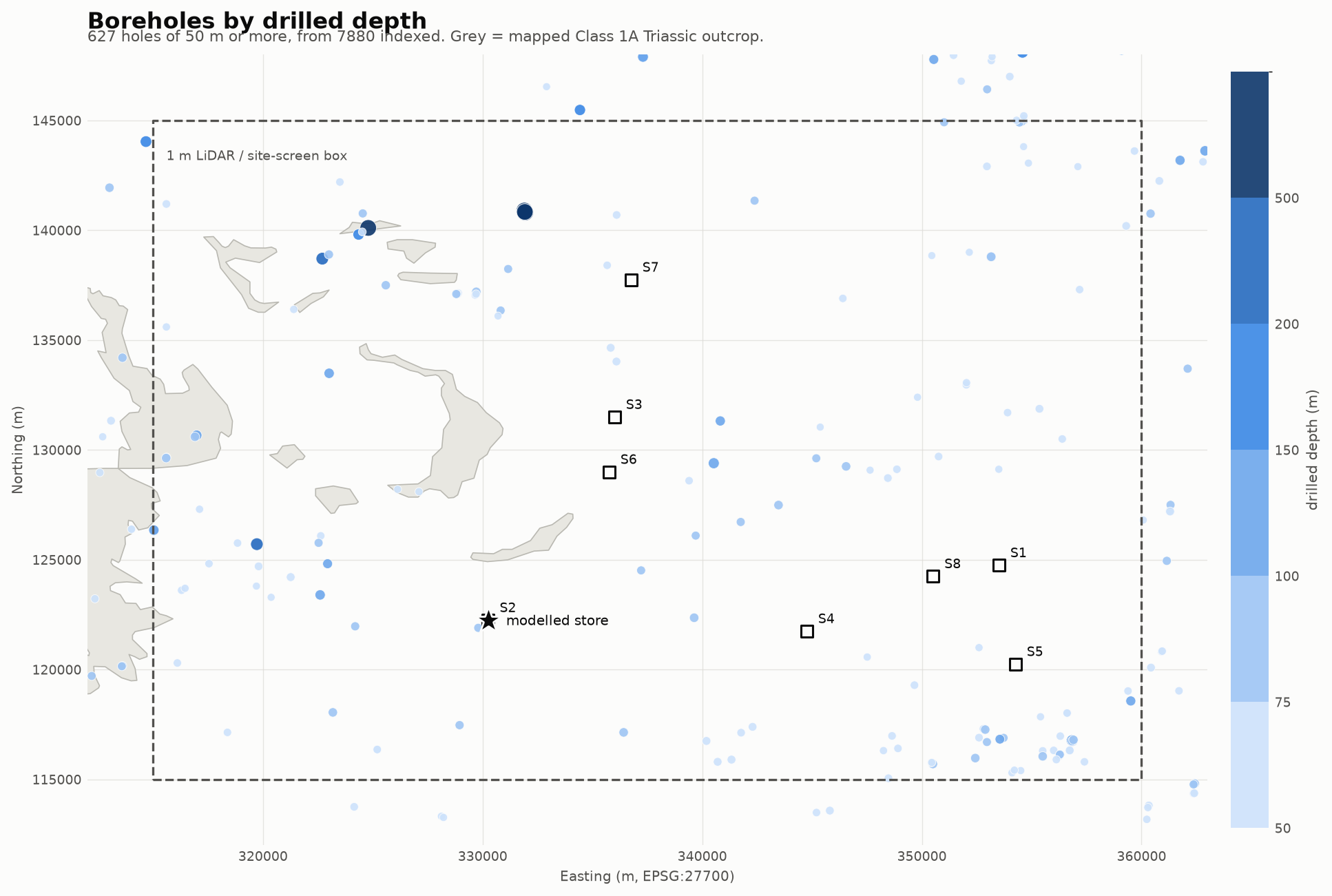
Depth is a magnitude, so it is encoded on a single hue, light to dark. Grey polygons are the mapped Class 1A Triassic outcrop — context only. They are not evidence of depth and they take no part in the rock map.
Two things are visible immediately:
- The deep holes cluster in the north, around Cannington (E325k N140k), not near the modelled store.
- The mapped Triassic outcrop is entirely in the west. The eastern half of the site box — where the three best reservoir sites are — has plenty of boreholes but no target aquifer beneath them.
Resolution actually achievable inside the site box (1350 km²)
| threshold | holes in box | mean spacing |
|---|---|---|
| ≥200 m | 7 | 13.9 km |
| ≥150 m | 9 | 12.2 km |
| ≥100 m | 19 | 8.4 km |
| ≥75 m | 57 | 4.9 km |
| ≥50 m | 145 | 3.1 km |
| ≥30 m | 313 | 2.1 km |
This table is the reason the ≥50 m tier is not optional. At the ≥100 m spacing of 8.4 km a fitted surface would smooth straight over the Cannington basement high — a feature we have already proved exists and which is about 10 km across. 161 of the 180 ≥100 m holes lie outside the site box, 66 of them in the Bath/Bristol fringe, a different basin.
3. What has been read
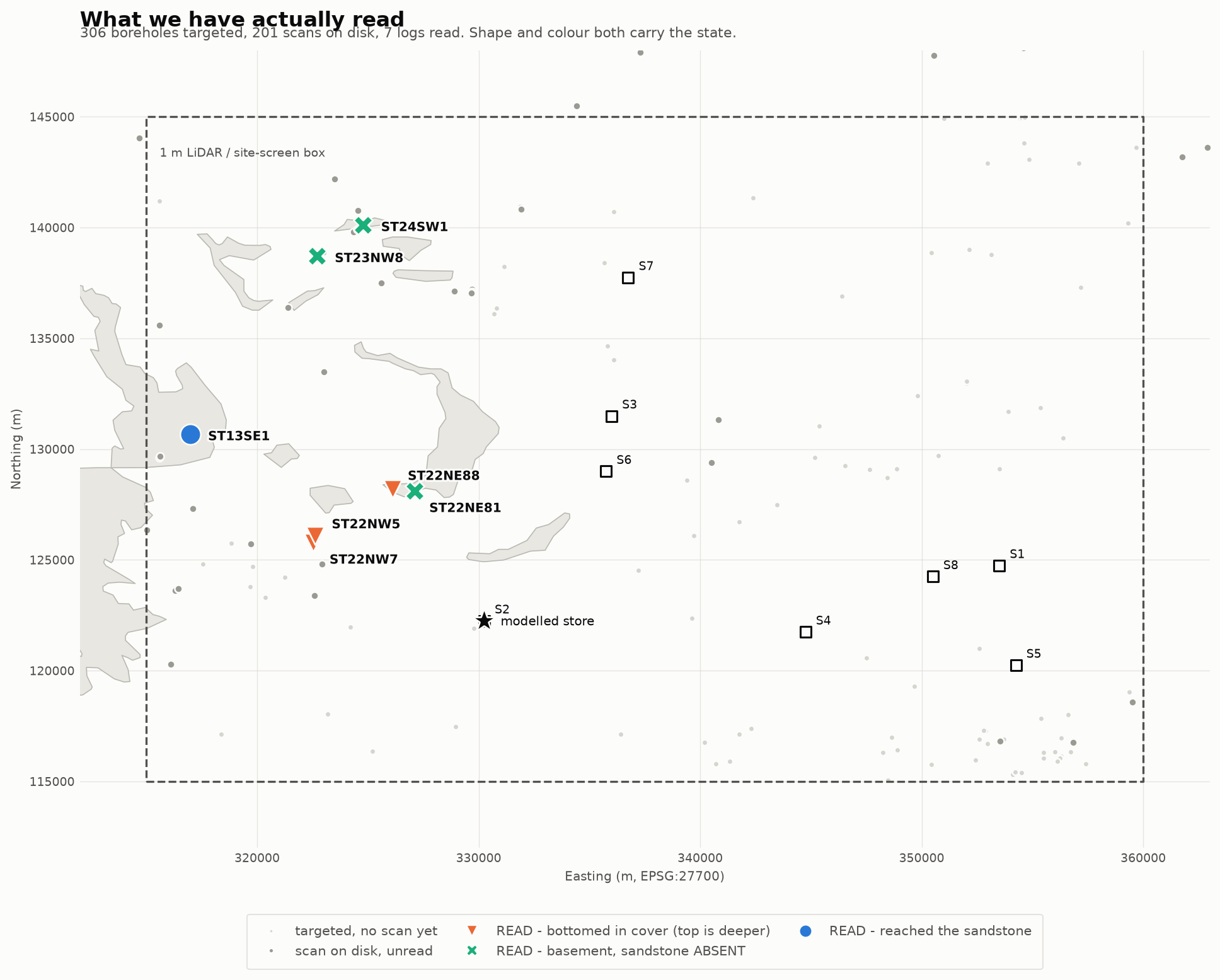
Shape and colour both carry the state, so identity never rests on colour alone. The table below is the same data in text — it is also the accessibility fallback for the one palette slot that sits below 3:1 contrast on this surface.
| ref | E | N | km to store | depth | observation |
|---|---|---|---|---|---|
| ST32SW1 | 330580 | 124310 | 2.1 | 32 m | top > 32 m (bottomed in cover) |
| ST22NE81 | 327100 | 128100 | 6.7 | 53 m | ABSENT — Devonian slate at 4.0 m |
| ST22NE88 | 326129 | 128207 | 7.3 | 50 m | top > 50 m (bottomed in cover) |
| ST22NW5 | 322630 | 126090 | 8.5 | 59 m | top > 59 m (bottomed in cover) |
| ST22NW7 | 322530 | 125770 | 8.5 | 78 m | top > 78 m (bottomed in cover) |
| ST13SE1 | 316980 | 130670 | 15.7 | 128 m | top 28.6 m, base 111.9 m — 83.2 m thick |
| ST23NW8 | 322700 | 138710 | 18.1 | 210 m | ABSENT — Devonian slate at 5.1 m |
| ST24SW1 | 324790 | 140110 | 18.7 | 1153 m | ABSENT — Carboniferous Limestone at 7.6 m |
Of eight holes, one reaches the aquifer, three prove it absent, and four only establish that it is deeper than they went.
All eight sit on ground the 625k map calls Triassic. The polygons would have reported “aquifer present” at every one of them.
The one positive result
ST13SE1, Bishops Lydeard — the Survey’s own margin classification, translated through the WD/97/34 p.284 nomenclature table:
| Survey term | modern name | depth | thickness |
|---|---|---|---|
| Keuper Marl | Mercia Mudstone Gp | 0 – 28.65 m | 28.7 m cover |
| Upper Sandstone | Otter Sandstone Fm | 28.65 – 59.4 m | 30.8 m |
| Bunter Pebble Beds | Budleigh Salterton Pebble Beds | 59.4 – 111.86 m | 52.4 m |
| Lower Marl | Aylesbeare Mudstone Gp | 111.86 – 128.02 m | base reached |
Even this positive result reads thin. WD/97/34 puts the Otter Sandstone at ~70 m near Wellington and up to 140 m further south; here it is 30.8 m. The Pebble Beds, which the reference calls “typically 20 to 30 m”, are 52.4 m — so most of the section is conglomerate rather than the productive sandstone.
The three absences are not noise
Currypool and Knap Farm are 2.6 km apart with Devonian and Carboniferous basement at 5.1 m and 7.6 m. Bishops Lydeard, ~10 km south-west, has 83 m of sandstone. That is a basement high at Cannington, and the mapped northern outcrop there is a thin veneer over it, not aquifer.
4. Reading traps, recorded because we have hit them
- “Sandstone” in a driller’s log is not the Sherwood Sandstone. Skerry sandstones occur within the Mercia Mudstone (ST32SW1: the driller logged 4.6 m of sandstone, the Survey classified the whole section as Keuper Marl). The Devonian slates carry purple sandstone beds (ST23NW8). Both have already been misread as aquifer here.
- The scans have no OCR. Every page carries an identical 113-char BGS watermark and nothing else, so a text-layer check reports “369 of 369 pages have text” while the logs themselves are images. Reading is visual.
- Depth sentinels.
LENGTHuses −2 / −1 / 0 for “unknown”. Treating those as shallow inflates the shallow bucket and drags the median.
5. Where the data is thinnest
Depth of knowledge by radius from the modelled store:
| radius | deepest hole | n ≥50 m | n ≥100 m |
|---|---|---|---|
| 2 km | 79 m | 1 | 0 |
| 5 km | 82 m | 2 | 0 |
| 7.5 km | 82 m | 6 | 0 |
| 10 km | 122 m | 19 | 2 |
| 15 km | 208 m | 55 | 6 |
| 20 km | 1153 m | 94 | 18 |
Within 7.5 km of the store nobody has drilled deeper than 82 m, and the cover is proven to at least 78 m with its base not reached. The deepest local observation barely exceeds the known cover thickness, so the aquifer — if present — lies entirely below the local observation envelope. Everything said about it within 7.5 km is extrapolation.
6. Next
- Read the deep sweep (≥100 m) for full sections — top, base, thickness, water levels, yields with drawdown, salinity. These are the holes worth extracting everything from, so we are not re-opening them later.
- Read the ≥50 m in-box tier for top surface only — the lighter read, and the one that buys the 3.1 km resolution.
- Draw the rock map from the boreholes alone, then overlay the polygons. The polygons must not inform the drawing: they have now disagreed with the ground at four of eight sites, and that disagreement is only measurable if they are kept out of it.