The portfolio re-screen
Generated by screen_portfolio.py. Every unit we hold information on, re-tested against a LOWER bar - not 'is this the MAR store' but 'does this have any role in an integrated…
Generated by screen_portfolio.py. Every unit we hold information on, re-tested against a LOWER bar - not ‘is this the MAR store’ but ‘does this have any role in an integrated water portfolio’. Both bars are stated below so the change can be argued with.
1. The two bars
The strict bar - what every previous screen asked:
- intergranular flow - water moves between grains, not just in cracks, so what goes in can be found again
- enough mapped area near the Levels to hold a season’s water
- close enough to the store that conveyance is not the whole cost
- confined, or confinable, so the head can be driven up
- some direct evidence underground - a log, a level, a yield
The portfolio bar - what this module asks:
- ANY role in managing water: storage, local supply that offsets demand elsewhere, baseflow support, a seal over something else, or a boundary that tells us where a store stops
- evidence sufficient to say what the role IS - a role we cannot name is UNDECIDED, not a candidate
Roles are one-per-unit and mutually exclusive:
| role | means |
|---|---|
| STORE | accepts water and returns it ON DEMAND. The MAR test. |
| CONJUNCTIVE | yields locally. Not a managed store, but real water that offsets demand somewhere else. |
| BASEFLOW | releases to rivers and springs. Belongs in the FLOW accounting, never in the store. |
| SEAL | holds a store down. Its value is that it does NOT transmit water. |
| BOUNDARY | defines where a store stops. No water role at all, and still needed to size one. |
| CATCHMENT | surface-water ground. Its portfolio role is runoff and reservoir, not aquifer. |
| INERT | no role found under either bar. |
| UNDECIDED | the evidence does not name a role yet. |
2. Every unit in the column, re-tested
km2 is what OUR 50k model maps, not the 625k. A blank means the unit has no colour key yet, so its outcrop is unmeasured - which is itself a finding.
| code | unit | km2 | was | now | why |
|---|---|---|---|---|---|
| DYS | Dyrham Formation | - | INERT | BASEFLOW | RECLASSIFIED, NOT PROMOTED. BGS writes a spring line into its own lower-boundary definition - ‘a negative change of slope and/or LINE OF SEEPAGE that may correspond with a sandy bed’. That is a real water role and it is not storage: a perched horizon tens of metres thick, hundreds of metres above the Sherwood and not connected to it. |
| CHAM | Charmouth Mudstone Formation | 116.9 | INERT | INERT | Class 3, essentially no groundwater. |
| BVM | Black Ven Marl Member | 75.5 | INERT | INERT | Member of CHAM. Overburden. |
| BLI | Blue Lias Formation | 175.7 | INERT | INERT | Class 3. Overburden above the whole MMG. |
| SFSH | Saltford Shale Member | 23.9 | INERT | INERT | Member of BLI. Where it crops out the Sherwood is at its deepest - which is information, but not a role. |
| LANG | Langport Member | - | INERT | INERT | Penarth Group, entered through a composite polygon. No Lexicon entry read. |
| BAN | Blue Anchor Formation | - | SEAL | SEAL | Top of the MMG, inferred not clicked. |
| BCMU | Branscombe Mudstone Formation | 95.7 | SEAL | SEAL | Upper Mercia Mudstone - seal, further from the aquifer than SIM. Gypsum and anhydrite throughout. |
| AS | Arden Sandstone Formation | - | INERT | UNDECIDED | RE-OPENED BY THE RELAXED BAR. The memoir lists ‘sandstones in the Mercia Mudstone Group’ among the sources of small local supplies - and the Arden Sandstone is exactly that, a sandstone INSIDE the seal. Under the strict bar a thin bed inside a confining layer was not worth a second look. Under a portfolio bar a perched local supply above the main store is a different proposition. |
| SIM | Sidmouth Mudstone Formation | 521.4 | SEAL | SEAL | The seal, unchanged, and the relaxed bar does not touch it. Its base IS the top of the Sherwood by BGS’s own definition, so where it crops out the aquifer is one SIM-thickness down. Contains halite. |
| TPSF | Tarporley Siltstone Formation | - | SEAL | SEAL | Cover, often absent. Where present it is the unit immediately over the aquifer. |
| HEY | Helsby Sandstone Formation | 32.2 | STORE | STORE | The target, unchanged. Class 1A intergranular, confirmed by three clicks and by both penetrating boreholes. The 1:50k memoir names it (as Otter Sandstone) one of only two aquifers holding the district’s groundwater. |
| WSF | Wilmslow Sandstone Formation | - | UNDECIDED | UNDECIDED | Wilmslow Sandstone. Presence here has never been confirmed - it sits in the column because the Sherwood sequence has it, not because anything local found it. |
| CHE | Chester Formation | - | UNDECIDED | STORE | PROMOTED, AND THIS IS THE FIND. The memoir does not treat the pebble beds as a separate minor unit - it names ‘the COMBINED Budleigh Salterton Pebble Beds and Otter Sandstone’ as ONE of the district’s two aquifers. We have carried CHE as ‘basal SSG, unconfirmed at outcrop’ and modelled HEY alone. If the memoir is right, the target is the PAIR and our store may be under-drawn at its base. |
| WIV | Wiveliscombe Sandstones | 29.0 | INERT | CONJUNCTIVE | PROMOTED. Class 1B INTERGRANULAR, and the memoir names ‘the slightly less productive combined Wiveliscombe Sandstones and Vexford Breccias’ as the district’s SECOND aquifer - the only other one it recognises. The strict screen ruled it out at 19 km with no monitoring, and recorded at the time that this was a ruling on DISTANCE, not on the rock. Move the bar to portfolio and the distance objection weakens: a local supply does not have to be piped to the Levels to be worth having. |
| EXE | Exeter Group | - | INERT | CONJUNCTIVE | PROMOTED with WIV, same reasoning. Permian sandstone, Class 1B, and the published porosity is HIGHER than the Sherwood’s - 22.4% against 14.8% - at comparable transmissivity. |
| CDL | Clifton Down Limestone Formation | 32.4 | INERT | CATCHMENT | RECLASSIFIED. Karstic - flow through solution conduits, so injected water goes where the conduits go and arrives when they say. Still POOR for controlled storage. But it is the Cheddar and Wookey water: an existing public supply on an existing catchment, and in a portfolio view that is a resource already in use, not empty ground. |
| POB | Portishead Subgroup | 16.0 | INERT | BOUNDARY | Old Red Sandstone, Class 2C, fracture flow. A sandstone that does not store. Its portfolio value is structural: its upper boundary is the conformable base of the Carboniferous, so it is the floor beneath the Mendip karst. |
| MSL | Morte Slates Formation | 79.8 | INERT | CATCHMENT | 600-1500 m of slate. Not an aquifer under any bar, and nothing useful lies beneath it. It is the Brendon Hills and the Broomfield outlier - upland catchment. |
| TGR | Trentishoe Member | 22.1 | INERT | BOUNDARY | The Quantocks. Fissure flow only, per the memoir. Its role is structural and it is a real one: this outcrop is the core of the QUANTOCK ANTICLINE, which the memoir makes the divider between the two Triassic basins - and the Central Somerset Basin is the one our Sherwood sits in. It marks the western limit of the aquifer basin. |
3. The 625k sweep, with the strict filters OFF
The standing report queries the 625k with two filters: CLASS in ['1A', '1B', '1C', '2A', '2B'] and within 25 km. Those filters ARE the strict bar. Re-run at 45 km with no class filter, 18 of 26 rows appear that the standing table cannot show - 4284 km2 of ground.
This section measures from the PROPOSED STORE, and that origin is itself a design assumption. It is kept because it is what found the Bridport Sand. For coverage questions use
papers/aquifers/aquifer_inventory.md, which measures from the site-screen BOX and locates every body - the same ground gives 26 units from the store and 335 located bodies from the box.
Rows the standing report already shows are marked shown. The rest are what the filters hid.
| unit | class | flow | km2 | nearest | in the standing table? |
|---|---|---|---|---|---|
| White Chalk Subgroup | 2A | fractures | 2151 | 13.6 km | shown |
| Triassic Rocks (Undifferentiated) | 2C | fractures | 1326 | 0.0 km | hidden |
| Lias Group | 3 | fractures | 1302 | 1.2 km | hidden |
| Kellaways Formation And Oxford Clay Formation (Undifferentiated) | 3 | fractures | 456 | 25.4 km | hidden |
| Upper Greensand Formation | 1B | intergranular | 446 | 6.5 km | shown |
| Great Oolite Group | 2B | fractures | 442 | 14.2 km | shown |
| Upper Devonian Rocks (Undifferentiated) | 2C | fractures | 307 | 7.0 km | hidden |
| Permian Rocks (Undifferentiated) | 1B | intergranular | 247 | 18.8 km | shown |
| Triassic Rocks (Undifferentiated) | 1A | intergranular | 241 | 2.7 km | shown |
| Permian Rocks (Undifferentiated) | 3 | fractures | 207 | 20.5 km | hidden |
| Dinantian Rocks (Undifferentiated) | 2B | fractures | 185 | 18.8 km | shown |
| West Walton Formation, Ampthill Clay Formation And Kimmeridge Clay Formation (Undifferentiated) | 3 | fractures | 170 | 39.6 km | hidden |
| Middle Devonian (Undifferentiated) | 2C | fractures | 150 | 13.2 km | hidden |
| Holsworthy Group | 2C | fractures | 149 | 18.1 km | hidden |
| Corallian Group | 2B | fractures | 101 | 36.3 km | hidden |
| Grey Chalk Subgroup | 2A | fractures | 95 | 9.6 km | shown |
| Inferior Oolite Group | 2A | fractures | 79 | 11.6 km | shown |
| Triassic Rocks (Undifferentiated) | 2B | fractures | 71 | 32.5 km | hidden |
| Bridport Sand Formation | 1B | intergranular | 20 | 26.4 km | hidden |
| Pennine Lower Coal Measures Formation And South Wales Lower Coal Measures Formation (Undifferentiated) | 2B | fractures | 9 | 41.5 km | hidden |
| Teign Valley Group | 2C | fractures | 9 | 22.4 km | hidden |
| Pennine Middle Coal Measures Formation And South Wales Middle Coal Measures Formation (Undifferentiated) | 2B | fractures | 4 | 44.1 km | hidden |
| Unnamed Extrusive Rocks, Silurian | 2C | fractures | 2 | 41.2 km | hidden |
| Unnamed Extrusive Rocks, Permian | 2C | fractures | 2 | 36.6 km | hidden |
| Lower Devonian Rocks (Undifferentiated) | 2C | fractures | 0 | 19.8 km | hidden |
| Gault Formation | 3 | fractures | 0 | 33.4 km | hidden |
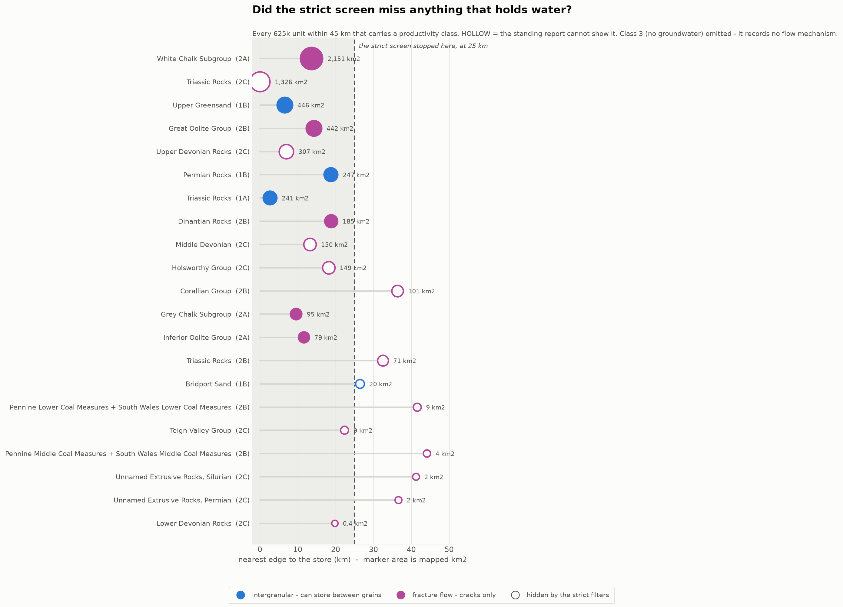
The only thing in that hidden set that could store water between grains:
- Bridport Sand Formation - class 1B, 20 km2, 26.4 km from the store
4. What moved when the bar moved
DYS - Dyrham Formation: INERT -> BASEFLOW
RECLASSIFIED, NOT PROMOTED. BGS writes a spring line into its own lower-boundary definition - ‘a negative change of slope and/or LINE OF SEEPAGE that may correspond with a sandy bed’. That is a real water role and it is not storage: a perched horizon tens of metres thick, hundreds of metres above the Sherwood and not connected to it.
Still missing: Its RGB, so the outcrop can be measured. Dyrham is confirmed by click and still has no colour key, because ‘dark salmon’ collides with the two Mercia Mudstone pinks that carry the depth story.
AS - Arden Sandstone Formation: INERT -> UNDECIDED
RE-OPENED BY THE RELAXED BAR. The memoir lists ‘sandstones in the Mercia Mudstone Group’ among the sources of small local supplies - and the Arden Sandstone is exactly that, a sandstone INSIDE the seal. Under the strict bar a thin bed inside a confining layer was not worth a second look. Under a portfolio bar a perched local supply above the main store is a different proposition.
Still missing: Whether AS is mappable here at all. It has no colour bin, no thickness, and may be too thin to appear at 1:50k. If it cannot be mapped it cannot be counted, however attractive the memoir sentence is.
CHE - Chester Formation: UNDECIDED -> STORE
PROMOTED, AND THIS IS THE FIND. The memoir does not treat the pebble beds as a separate minor unit - it names ‘the COMBINED Budleigh Salterton Pebble Beds and Otter Sandstone’ as ONE of the district’s two aquifers. We have carried CHE as ‘basal SSG, unconfirmed at outcrop’ and modelled HEY alone. If the memoir is right, the target is the PAIR and our store may be under-drawn at its base.
Still missing: Whether BGS’s Chester Formation (CHE) and the Budleigh Salterton Pebble Beds are one unit here or two - the Milverton click returned ‘Chester Formation-Conglomerate’ and the memoir says Budleigh Salterton. Read both Lexicon entries before the store is re-sized. This is the single highest-value unread page in the project.
WIV - Wiveliscombe Sandstones: INERT -> CONJUNCTIVE
PROMOTED. Class 1B INTERGRANULAR, and the memoir names ‘the slightly less productive combined Wiveliscombe Sandstones and Vexford Breccias’ as the district’s SECOND aquifer - the only other one it recognises. The strict screen ruled it out at 19 km with no monitoring, and recorded at the time that this was a ruling on DISTANCE, not on the rock. Move the bar to portfolio and the distance objection weakens: a local supply does not have to be piped to the Levels to be worth having.
Still missing: Any measurement at all. There is no Lexicon entry (the portal returns ‘no details’), no thickness, no boundaries, and no monitoring. Its GROUP is inferred rather than clicked - the only such entry in the key.
EXE - Exeter Group: INERT -> CONJUNCTIVE
PROMOTED with WIV, same reasoning. Permian sandstone, Class 1B, and the published porosity is HIGHER than the Sherwood’s - 22.4% against 14.8% - at comparable transmissivity.
Still missing: Whether the porosity advantage survives locally. Those are regional figures and we hold no Permian parameters in core/aquifer_reference.py, which carries TRIASSIC and CHALK only.
CDL - Clifton Down Limestone Formation: INERT -> CATCHMENT
RECLASSIFIED. Karstic - flow through solution conduits, so injected water goes where the conduits go and arrives when they say. Still POOR for controlled storage. But it is the Cheddar and Wookey water: an existing public supply on an existing catchment, and in a portfolio view that is a resource already in use, not empty ground.
Still missing: Nothing, for our purposes. The verdict is stable in both directions - it is a real aquifer and it is not ours.
POB - Portishead Subgroup: INERT -> BOUNDARY
Old Red Sandstone, Class 2C, fracture flow. A sandstone that does not store. Its portfolio value is structural: its upper boundary is the conformable base of the Carboniferous, so it is the floor beneath the Mendip karst.
Still missing: Which of its 11 polygons are real. Only 8.9 km2 of the 16.0 sits on 625k ground of the right age - 45% agreement, second-weakest on the map.
MSL - Morte Slates Formation: INERT -> CATCHMENT
600-1500 m of slate. Not an aquifer under any bar, and nothing useful lies beneath it. It is the Brendon Hills and the Broomfield outlier - upland catchment.
TGR - Trentishoe Member: INERT -> BOUNDARY
The Quantocks. Fissure flow only, per the memoir. Its role is structural and it is a real one: this outcrop is the core of the QUANTOCK ANTICLINE, which the memoir makes the divider between the two Triassic basins - and the Central Somerset Basin is the one our Sherwood sits in. It marks the western limit of the aquifer basin.
5. The UNDECIDED, and what would settle each
A role we cannot name is not a candidate. These are the observations that would move them.
- WSF (Wilmslow Sandstone Formation) - One click or one log inside the Sherwood outcrop that returns WSF rather than HEY.
- AS (Arden Sandstone Formation) - Whether AS is mappable here at all. It has no colour bin, no thickness, and may be too thin to appear at 1:50k. If it cannot be mapped it cannot be counted, however attractive the memoir sentence is.
6. Coverage of this screen
- units in the column: 20, assessed here: 20
- every unit in the column has a row above
- the 625k sweep covers 26 units, 8171 km2 within 45 km, at every class
- no parameter in this file is new. Where a number is quoted it comes from
core/stratigraphy.py, the 625k attributes, or the 1:50k Taunton memoir.