The rhynes - the low-level watercourses
Generated by build_rhynes.py. The drainage network of the Levels, which every previous dataset in this project left out.
Generated by build_rhynes.py. The drainage network of the Levels, which every previous dataset in this project left out.
The objective of this study is drought mitigation for farmers and for the environment, and the environmental half was phrased as returning water to low-level watercourses if we can. Until this chapter the project contained no such watercourses. core/rivers.py fetches OS Open Rivers, which carries the Parrett, Tone, Brue and their kin - the channels that take water out of the Levels. The rhynes, which are where water on the Levels actually sits, were in no dataset here.
1. What is there
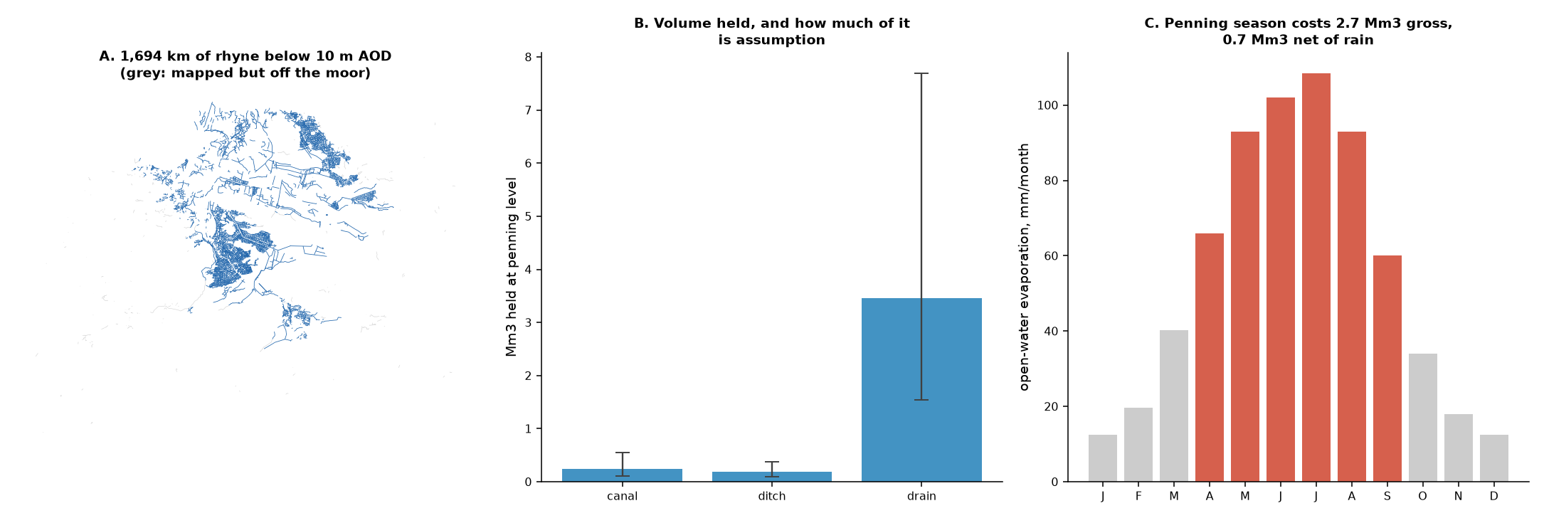
- 1,789 km of
drain,ditchandcanalmapped in OpenStreetMap over the DEM box - 1,694 km of it below 10 m AOD - 95% - which is the moor floor and the part that behaves as Levels drainage
- 5,427 separate ways; only 5% carry a name
| class | ways | km on moor | assumed width | water area km2 | held volume Mm3 |
|---|---|---|---|---|---|
| canal | 18 | 28 | 12 m | 0.33 | 0.25 |
| ditch | 663 | 127 | 2 m | 0.25 | 0.19 |
| drain | 4,746 | 1,539 | 3 m | 4.62 | 3.46 |
| total | 5,427 | 1,694 | 5.20 | 3.90 |
canal is kept separate rather than averaged in because it is the engineered cuts - the Huntspill River and King’s Sedgemoor Drain - which are an order of magnitude wider than a field rhyne and would distort a single mean width.
2. Why flat ground changes the model rather than simplifying it
The instinct that flat ground is easy is half right, and the half that is wrong decides the method.
Flatness makes the geometry easy: a level surface over a known area is a volume, which is the table above. It makes the hydraulics meaningless. At gradients of order 1:10,000 the water surface is set by structures - penning boards, sluices, tilting weirs and pumps - and the channel bed barely participates. Routing water down a slope that is not there would be a model of nothing.
So the rhynes are modelled as a level-controlled storage, not as a routed network. The state variable is the penned level; the fluxes are evaporation off the surface, seepage to and from the peat, whatever is let in at the top, and the pumped or gravity outfall at the bottom. This is the same modelling decision, for the same reason, that makes the aquifer a storage account rather than a groundwater simulation.
It also means the tidal boundary matters again. The project set it aside on the grounds that it only binds if flood attenuation is claimed. That remains true for attenuation - but a level-controlled system whose outfall is tide-locked cannot be drawn down on demand either, so any operating rule that assumes the moors can be emptied to make room is assuming an outlet the system does not always have.
3. The demand nobody had counted
Holding a summer penning level costs water. Over the 183-day season (April-September), open-water evaporation on 5.20 km2 of rhyne surface is:
- 522 mm of evaporation, = 2.72 Mm3 gross
- less 391 mm of rainfall on the same surface
- = 0.69 Mm3 net over the season
That is a floor, not the requirement. It counts evaporation and nothing else. Seepage into the peat, leakage past structures and water taken off for stock are all real, all larger in aggregate than this, and none is quantified here. The true penning demand is some multiple of the number above and the multiple is unknown.
Even so, the floor is worth comparing to the scheme:
| quantity | Mm3 |
|---|---|
| water held in the rhynes at penning level | 3.90 |
| evaporative cost of holding it, per season (floor) | 0.69 |
| irrigation demand assumed in the scheme runs, per year | 3.00 |
| river support delivered by run 07 over 16.5 yr | 13.73 |
The rhynes hold 1.3x the volume the entire scheme irrigates with in a year, and keeping them penned through one summer costs at least 18% of that stored volume again. A scheme that returns water to the Levels is not topping up a rounding error; it is supplying a store of comparable size to the one it was built for.
4. What this licenses, and what it does not
Licensed: treating the rhynes as a named, located, level-controlled store of stated size; using that as the destination for environmental releases rather than a main river; and putting a floor under the penning demand.
Not licensed:
- The volume. Every metre of it rests on an assumed width (drain 3 m, ditch 2 m, canal 12 m) and an assumed held depth (0.75 m). Across the stated ranges the total moves from 1.75 to 8.63 Mm3 - a factor of 4.9. No cross-section anywhere in this project has been measured.
- The network length. OSM ditch mapping is uneven and a missing rhyne is invisible, so the length is a lower bound. It is not a survey.
- The penning levels themselves. These are IDB operational data (Somerset Drainage Boards Consortium) and were not found in any open dataset. The seasonal regime here is the documented general practice, not this catchment’s actual operating rules.
- Seepage, in either direction. Peat is not impermeable and the exchange between rhyne and moor is a real term of unknown sign in winter and unknown size in summer.
- Any ecological requirement. Which moors need what level, when, and for which species, is a question for the local ecology and site condition assessments. The designated-site polygons are already fetched by
core/constraints.py; the water requirements attached to them are not.
Network from OpenStreetMap, © OpenStreetMap contributors, ODbL. Elevations from the project’s 50 m DEM.