Rock layers, drawn from the boreholes
Generated by build_rock_layers.py. The polygons take no part in the drawing - they are scored against it below.
Generated by build_rock_layers.py. The polygons take no part in the drawing - they are scored against it below.
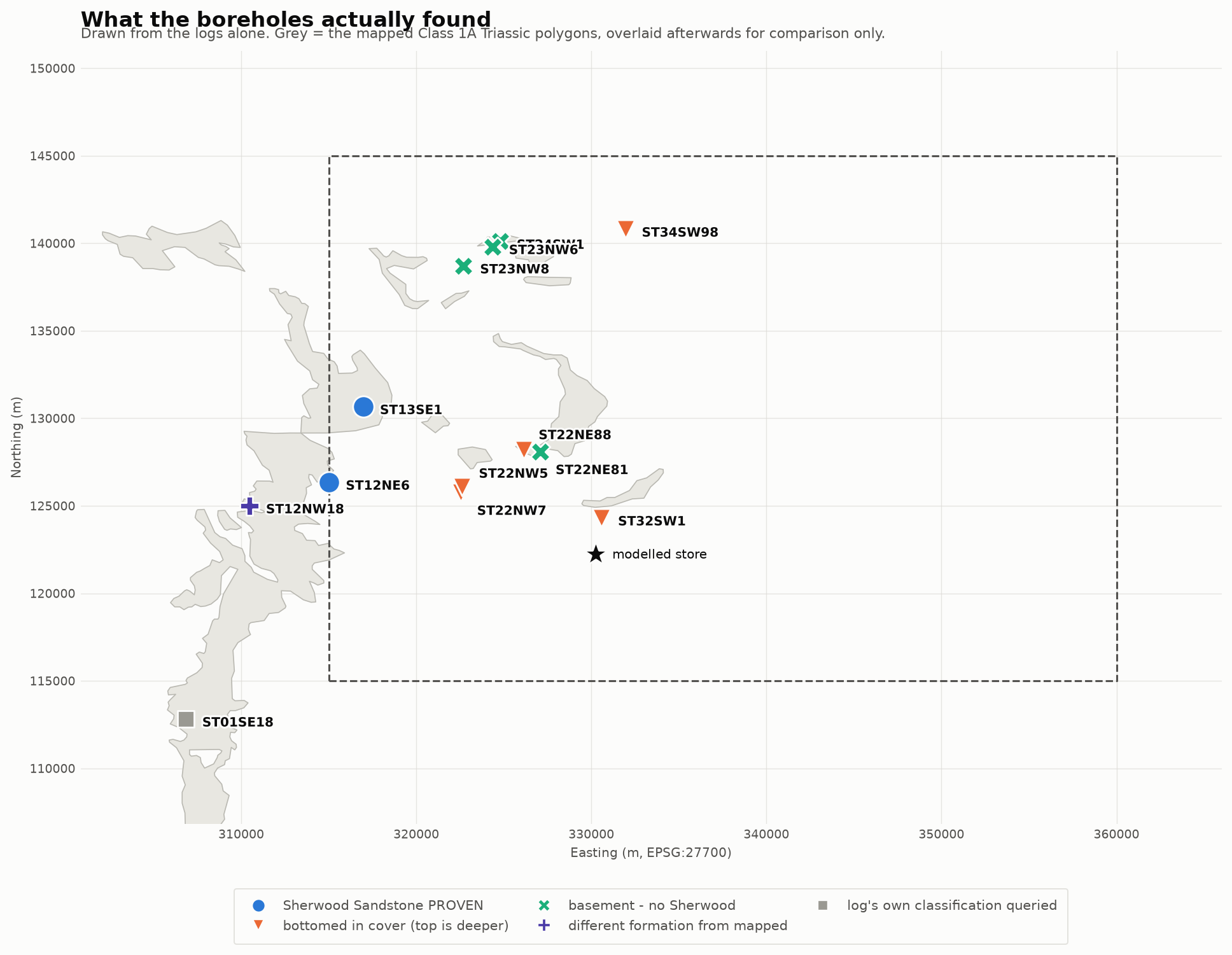
Every observation
| ref | E | N | what the log shows | what the polygon claims |
|---|---|---|---|---|
| ST01SE18 | 306830 | 112820 | log’s own classification queried | TRIASSIC ROCKS (UNDIFFERENTIATED) (1A) |
| ST12NE6 | 315030 | 126350 | Sherwood Sandstone PROVEN | TRIASSIC ROCKS (UNDIFFERENTIATED) (2C) |
| ST12NW18 | 310470 | 125000 | different formation from mapped | TRIASSIC ROCKS (UNDIFFERENTIATED) (1A) |
| ST13SE1 | 316980 | 130670 | Sherwood Sandstone PROVEN | TRIASSIC ROCKS (UNDIFFERENTIATED) (1A) |
| ST22NE81 | 327100 | 128100 | basement - no Sherwood | TRIASSIC ROCKS (UNDIFFERENTIATED) (1A) |
| ST22NE88 | 326129 | 128207 | bottomed in cover (top is deeper) | TRIASSIC ROCKS (UNDIFFERENTIATED) (1A) |
| ST22NW5 | 322630 | 126090 | bottomed in cover (top is deeper) | TRIASSIC ROCKS (UNDIFFERENTIATED) (2C) |
| ST22NW7 | 322530 | 125770 | bottomed in cover (top is deeper) | TRIASSIC ROCKS (UNDIFFERENTIATED) (2C) |
| ST23NW6 | 324350 | 139810 | basement - no Sherwood | HOLSWORTHY GROUP (2C) |
| ST23NW8 | 322700 | 138710 | basement - no Sherwood | TRIASSIC ROCKS (UNDIFFERENTIATED) (2C) |
| ST24SW1 | 324790 | 140110 | basement - no Sherwood | TRIASSIC ROCKS (UNDIFFERENTIATED) (1A) |
| ST32SW1 | 330580 | 124310 | bottomed in cover (top is deeper) | TRIASSIC ROCKS (UNDIFFERENTIATED) (2C) |
| ST34SW98 | 331940 | 140810 | bottomed in cover (top is deeper) | LIAS GROUP (3) |
Where the map and the ground disagree
5 of 13 observations fall inside a polygon that claims a productive aquifer the borehole does not confirm. Only 2 hole in the whole set proves Sherwood Sandstone.
- ST24SW1 — polygon says TRIASSIC ROCKS (UNDIFFERENTIATED) (1A); the log shows basement - no Sherwood.
- ST22NE81 — polygon says TRIASSIC ROCKS (UNDIFFERENTIATED) (1A); the log shows basement - no Sherwood.
- ST22NE88 — polygon says TRIASSIC ROCKS (UNDIFFERENTIATED) (1A); the log shows bottomed in cover (top is deeper).
- ST01SE18 — polygon says TRIASSIC ROCKS (UNDIFFERENTIATED) (1A); the log shows log’s own classification queried.
- ST12NW18 — polygon says TRIASSIC ROCKS (UNDIFFERENTIATED) (1A); the log shows different formation from mapped.
This is not an argument that the mapping is bad. At 1:625,000 a polygon boundary is worth kilometres on the ground and BGS says so. It is an argument that the polygons cannot be used as evidence of aquifer presence at a point, which is exactly how the project’s area factor has been using them.
What cannot be drawn yet
A top surface needs points where the top is KNOWN. There is 2. One point defines no surface, so no interpolation is attempted here and none should be quoted. The censored observations bound the surface from above and the basement points fix where it terminates, but a fitted top needs more penetrating holes.